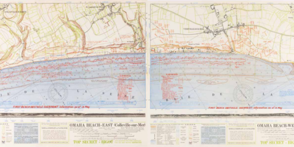
D-day: Atlantic Wall breached Just as travellers in a car hold a map in the direction they are headed, this map is oriented toward the beach, which is to the south. Based on intelligence efforts, the troops are aware of the obstacles they will encounter both on the way to the beach and on the…
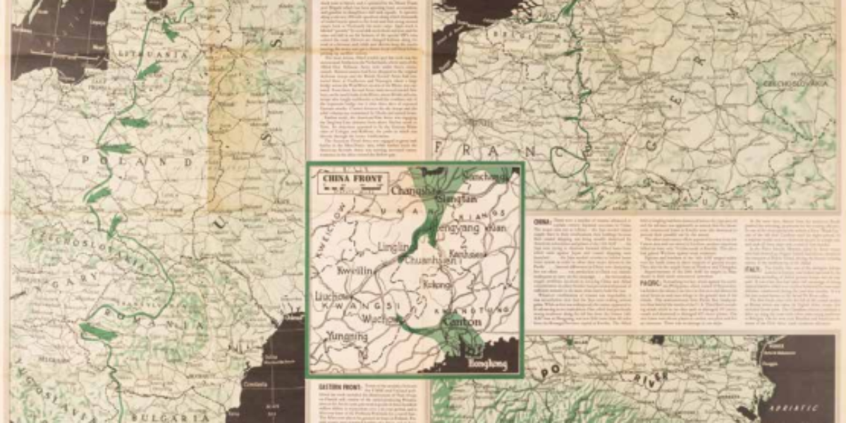
News of victories for own troops Every week, the U.S. military produces a poster-sized news map, featuring action arrows and explanatory notes. These maps are not intended for the general public but are distributed to military personnel worldwide, government officials, select libraries, and a single copy is provided to the U.S. House of Representatives. These…
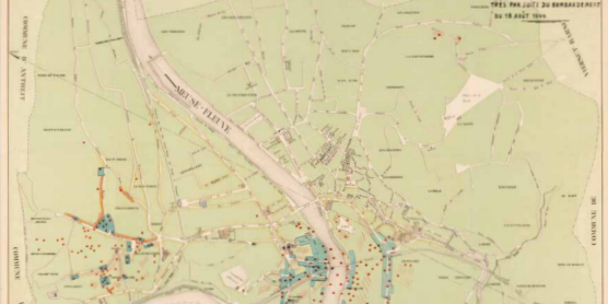
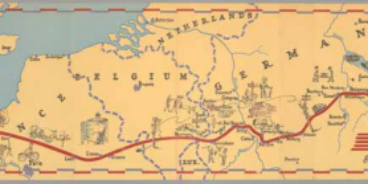
The price of rapid advance: Huy devastated On August 18, allied forces launched an aerial bombardment targeting the Meuse River bridges in Belgium. The bombing mission involved “flying fortresses” dropping bombs on multiple locations, including Huy, which is situated south of Liège. Unfortunately, most of the bombs do not hit the intended targets (except for…
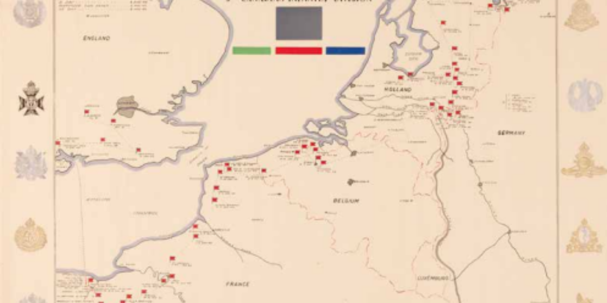
Canada liberates eastern and northern Netherlands In contrast to the style of the U.S. 79th Division’s memorial map, this Canadian map of their 3rd Division takes on a more formal and sombre appearance. Fags and dates indicate the shifting locations where the division headquarters was situated during its campaigns. The map highlights the strategic positioning…
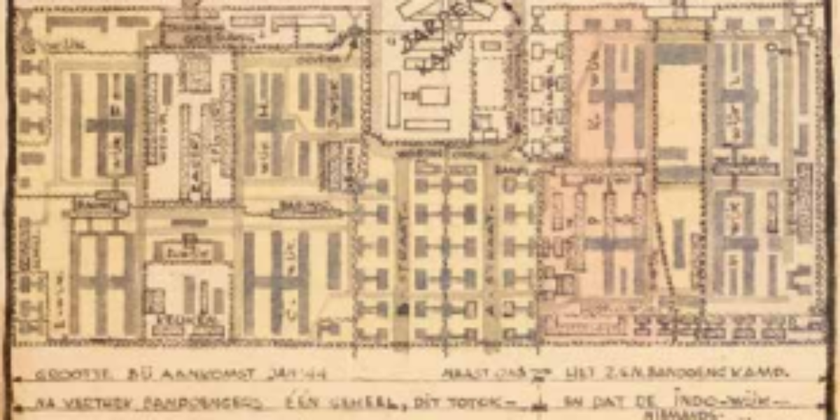
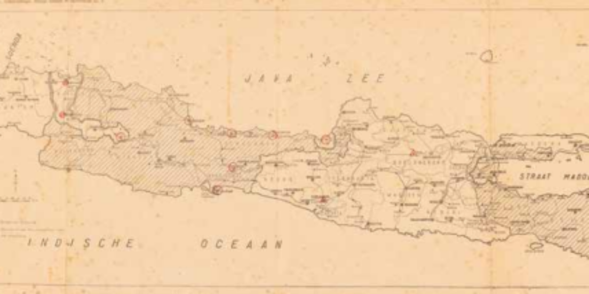
Endless internment in Bandung Shortly after the Allied capitulation in March 1942, Japan interned all Europeans in Indonesia. Men, women with small children, and teenage boys, were all placed in separate camps. Notably, the men’s camp, the boys’ camp, and the women’s camp were situated in close proximity to each other. The internment camps were…
Endless internment in Bandung Shortly after the Allied capitulation in March 1942, Japan interned all Europeans in Indonesia. Men, women with small children, and teenage boys, were all placed in separate camps. Notably, the men’s camp, the boys’ camp, and the women’s camp were situated in close proximity to each other. The internment camps were…
Escape maps for pilots These “escape maps” printed on artificial silk were initially kept as a secret. They served a crucial purpose for American pilots who might be shot down over the sea or enemy territory. If a pilot managed to save himself by parachuting to safety, these maps provided a valuable means of orientation….
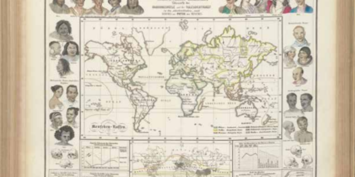
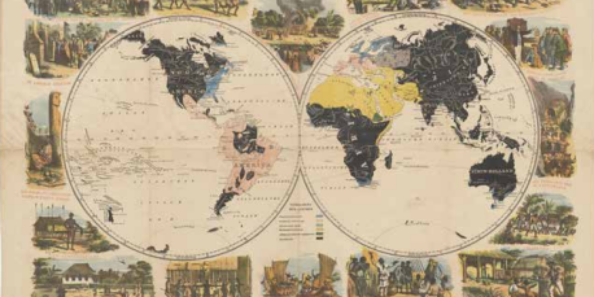
Distribution of human races Dr. Heinrich Berghaus played a pivotal role in advancing modern thematic cartography with his Physikalischer Atlas. The anthropographic atlas section includes a map that differentiates six distinct races. A wreath of representative heads showcases various skin colors, facial features, and skull shapes associated with these six racial groups. Unfortunately, racism also…
Mission postcard Mission cards, which reached their apex in the mid-19th century, play an important role in garnering financial support for the global dissemination of Christianity. During this period, missionary efforts were primarily focused on the colonies. However, it should be noted that some Christian missions also advocated for the liberation of Black individuals from…
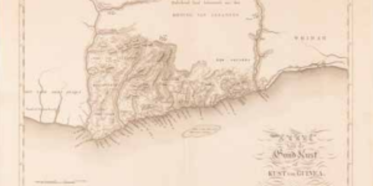
Map of the Dutch Gold Coast Following the capture of the Guinean fort St. George Del Mina in 1637, the fort expanded to become the Dutch Gold Coast. Equipped with factories, this fortress became the focal point for the West India Company (WIC) and their slave trading via Curaçao. In 1871, the Netherlands sells this…
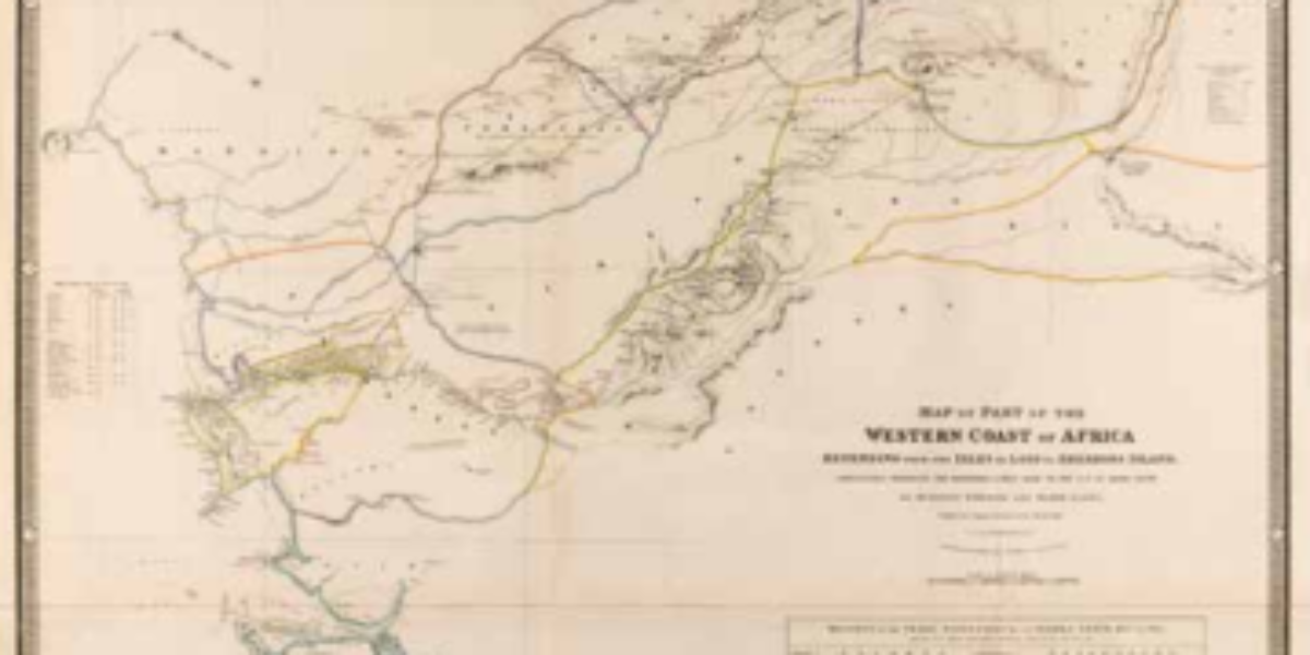
Return of enslaved people to West Africa This map of West Africa depicts in colours the routes of four expeditions conducted between 1794 and 1822, which aimed to explore the interior of Sierra Leone and a portion of Guinea. Two of the explorers were responsible for creating this map. Importantly, after the abolition of slavery,…
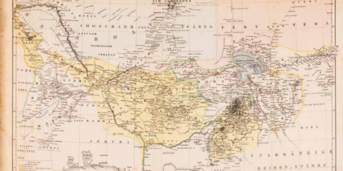
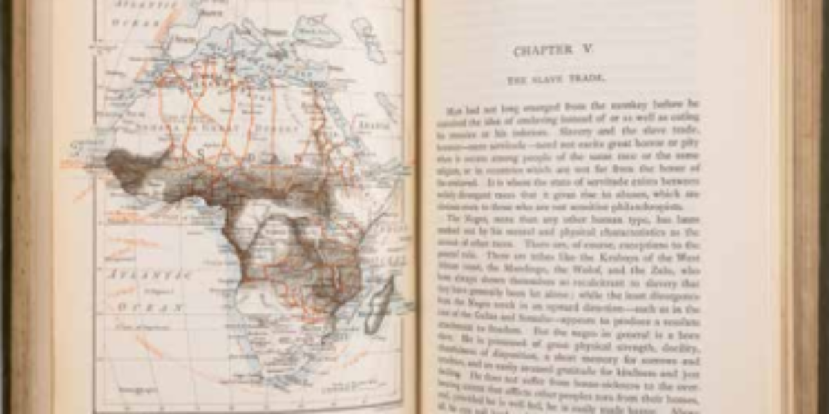
Slavery in the Sokotokaliphate Heinrich Barth, a German Arabist, provides an account of his ‘voyage of discovery’ through Central and West Africa, which is traced by the red lines on the map. Barth’s argument revolves around the idea that the ethnic identity of the peoples he encounters is determined by their history. During his expedition,…
Slave trade and colonisation Harry Johnston, an explorer and colonial administrator, was fluent in several African languages and wielded significant influence over British colonial policy. In the ‘British Central African Protectorate,’ he led battles against Muslim Swahili and Yao slave traders. His first map delineates the slave traders’ ‘hunting grounds,’ distinguishing them through light and…
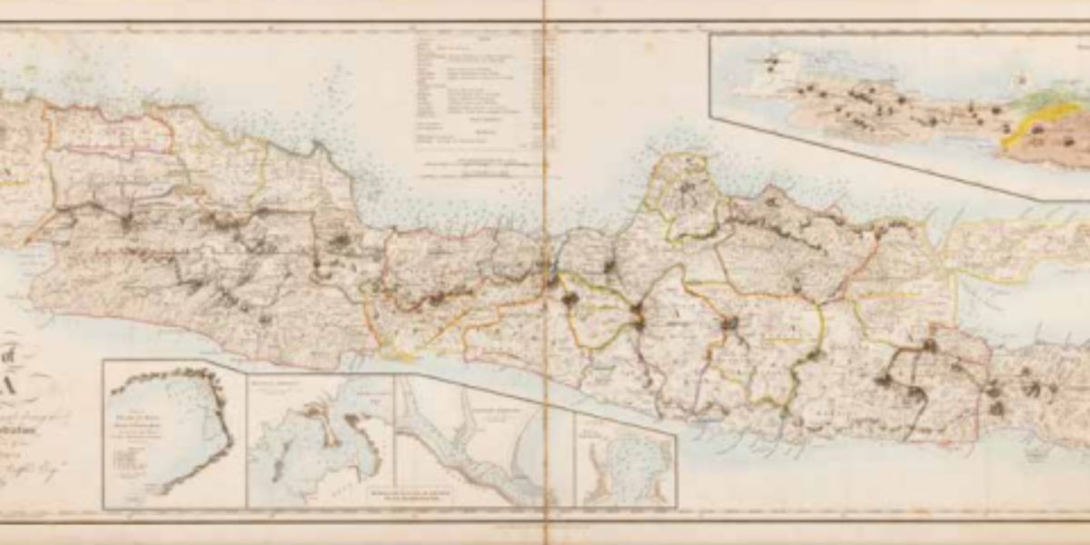
Map of British Java Following the French annexation of the Kingdom of Holland, Stamford Raffles leads a British military expedition against Java in 1811 and becomes lieutenant governor of the East Indies. During his tenure, cartographer J. Walker conducted land measurements and assigned geographical names, which form the basis for this fine topographical map of…
Netherlands’ bloodiest colonial war Cartographer Thomson became an infantry first lieutenant in the Royal Dutch East Indies Army (KNIL) in 1894. At that time, the Dutch had been embroiled in their bloodiest colonial conflict in the Sultanate of Aceh for decades. During his tenure as a member of parliament in 1906, Thomson criticised what he…
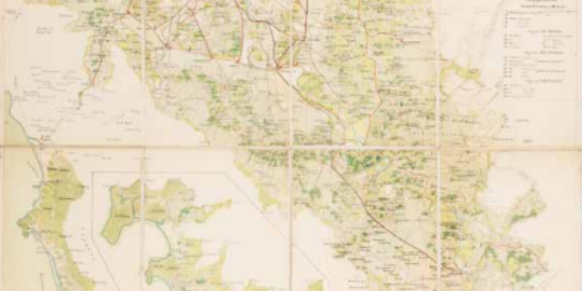
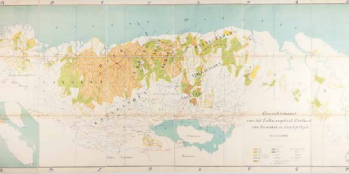
Kulie plantations on Sumatra’s east coast After 1970, Western entrepreneurs managed to secure extensive agricultural concessions on Sumatra’s east coast after 1870, especially for tobacco and rubber plantations (indicated in orange and green). Over time, these plantations account for 20% of the Dutch East Indies’ exports. High dividends for Dutch shareholders in these coolie plantations…
Prelude to ‘Police Action‘ Following Japan’s surrender, Sukarno proclaimed the Republik Indonesia on 17 August 1945. The Netherlands does not recognise the Republik and at most wants to introduce a federal form of state under the Crown. This March 1947 map is published during the prelude to the first ‘police action’ that culminates in numerous…
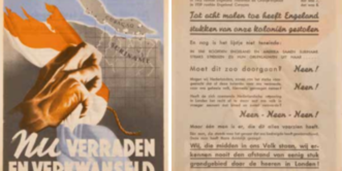
NSB pamphlet Suriname and Curaçao As represented in this pamphlet, the National Socialist Movement (NSB) takes issue with Britain and America foreign policies. It was prompted by the Dutch government-in-exile’s permission in November 1941 to station American troops in Suriname to protect the bauxite mines (a raw material essential for the production of aluminium). At…
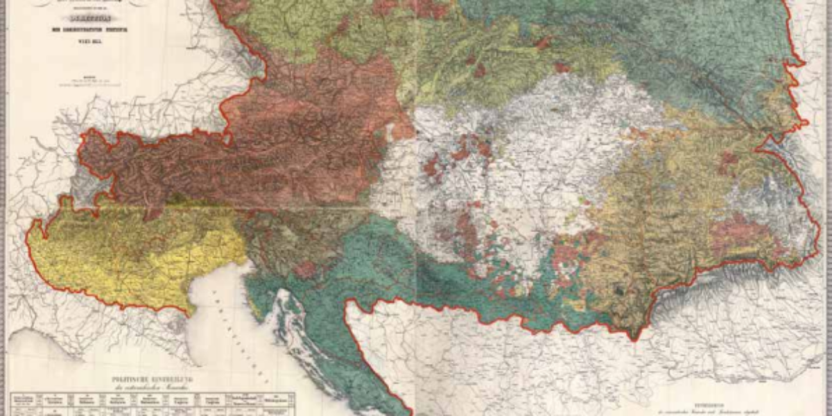
Ethnographic map Austrian monarchy Karl von Czoernig, the chief statistical officer of Austria, used this map to envision a restored Habsburg order after the national uprisings of 1848. The multiplicity of nationalities here does not yet rule out political unity, nor do the 14 language branches here cross imperial borders.
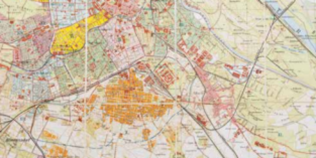
Capital of ‘Kakania‘ Since 1867, Vienna has served as the capital of ‘Kakania,’ an ironic term referring to the ‘kaiserlich-königlichen Doppelmonarchie Österreich-Ungarn.’ The map illustrates the old city centre (I) and the desolate slums located beyond it (e.g., II and VII). Due to the rapidly increasing population, new neighbourhoods (XXI and X) are being constructed…
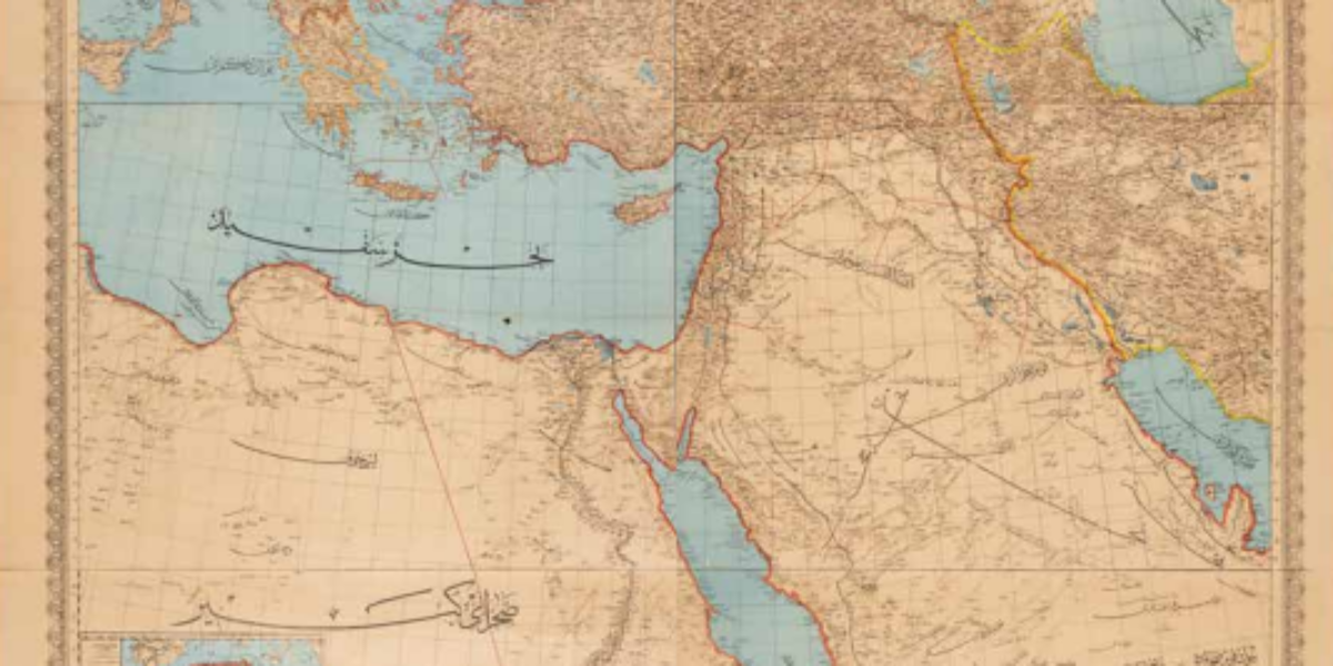
Map of the Greater Ottoman Empire This map of the Ottoman Empire depicts a vast empire spanning three continents, but there are some notable issues with its red outer borders: Bosnia-Herzegovina is still depicted as part of the Ottoman Empire, despite being occupied since 1878 and annexed by Austria-Hungary in 1908. Bulgaria is shown as…
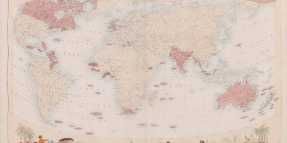
The British Empire under George V During the 19th century, the rose-red British Empire was characterised by its pursuit of raw materials for industry and the creation of markets for its manufactured goods. Congruently, it also required the establishment of strategic naval bases and supply stations around the world. This map reflects the belief in…
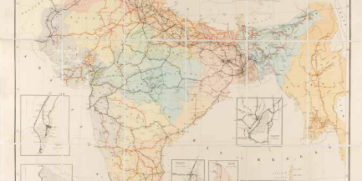
Railways in the British East Indies British India (1858-1947) comprises the present-day countries of India, Pakistan, Bangladesh, Sri Lanka and Myanmar, and is considered the ‘crown jewel’ of the British empire. The Indian railway system plays a pivotal role in the development of infrastructure, including the construction of dams, aqueducts, bridges, and the transport of…
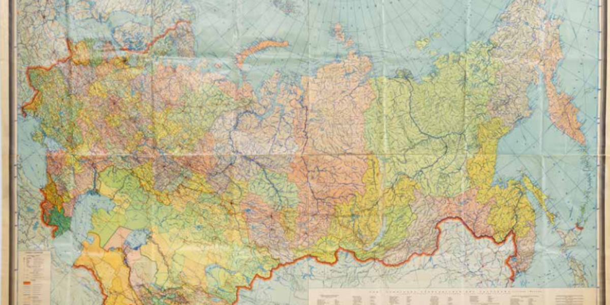
European Russia and Siberia This hand-painted ‘map of European Russia and Siberia’ with inset map ‘Asian Russia’ depicts the administrative division of the tsarist empire into various governorates and their respective provinces. This modern map provides detailed information on areas, population figures, and distances. The Russian Empire was characterised by its multilingual and multi-religious composition;…
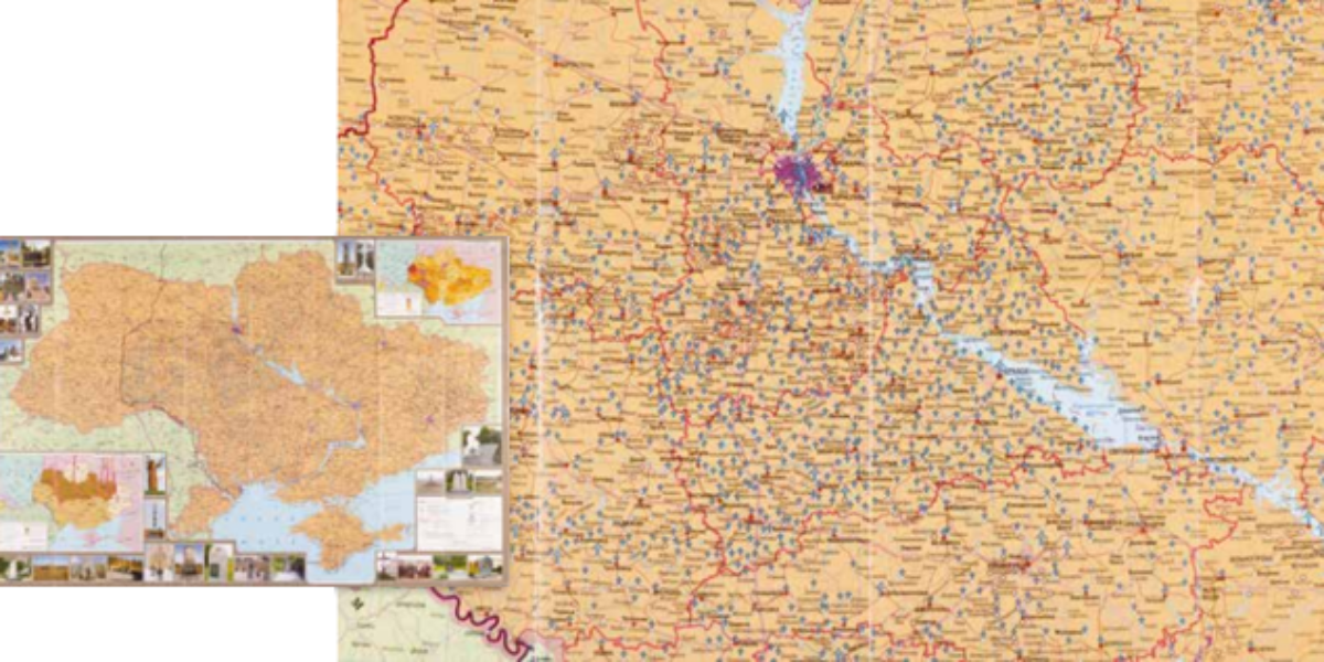
Four million starvation deaths in Ukraine On the largest map, innumerable blue markers indicate the memorials and monuments erected to commemorate the victims of Holodomor, the devastating genocide by starvation that occurred in 1932-’33. Over five million people perished, four million in Ukraine alone. The yellow crosses refer to the few pre-1990 memorial plaques.
Soviet Union tablecloth This plasticised map of the Union of Soviet Socialist Republics (USSR), with its division into formal republics and constituent republics, portrays the vast Russian empire in a dominant red colour. At the time of the USSR’s establishment, each republic was granted the right of secession (which would later be exercised by all…
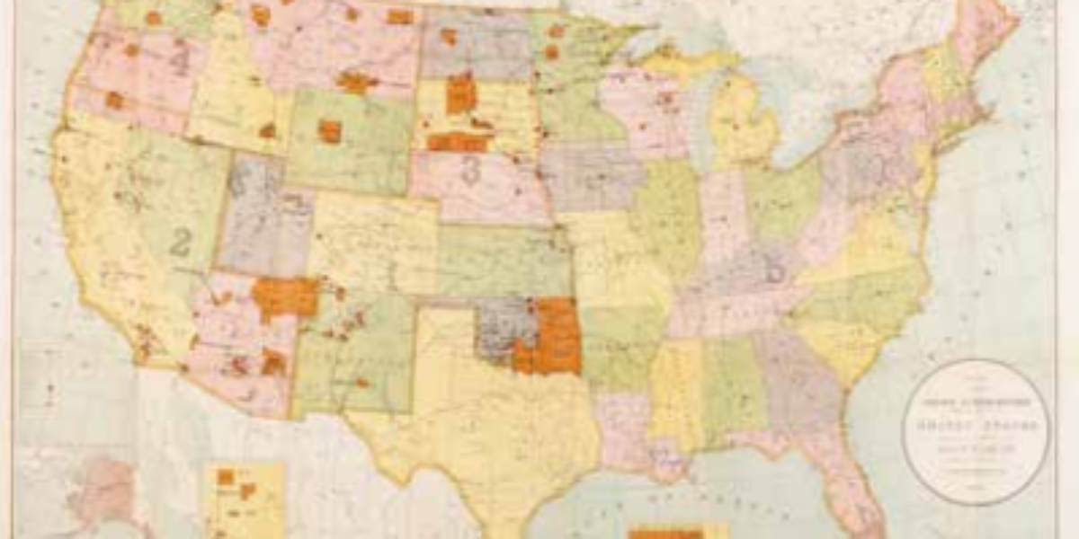
‘Kill the Indian, save the man‘ This map illustrates the remaining tribal areas of Native Americans following a devastating history of epidemics, conflicts, and ethnic cleansing during the era of westward expansion in the United States. Aside from the remaining reservations, the map also highlights the 22 boarding schools for Native American children, denoted by…
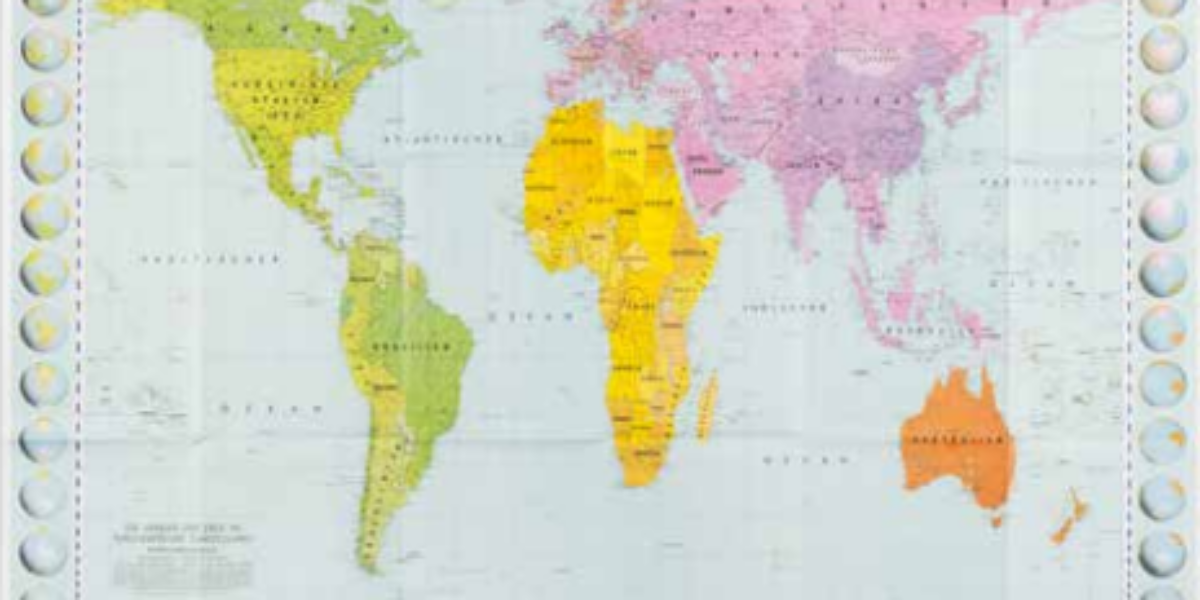
Controversial Peters projection On the traditional Mercator-projected world map, Europe appears much larger than South America, even though in reality it covers only a third of its area. Additionally, the map by the 16th-century geographer Mercator gives more emphasis to the northern hemisphere. East German cartographer Peters challenged this Eurocentric view by introducing a new…
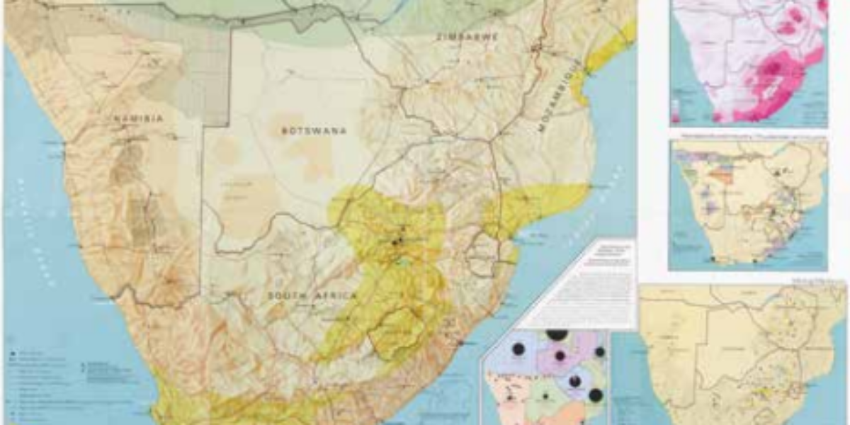
Oppression and resistance in South Africa This map is part of the Komitee Southern Africa’s (KZA) educational folder titled ‘This is Apartheid.’ Apartheid was a system that enforced racial segregation, separating people into categories such as Bantus, Coloureds, Asians, and Whites. Black people residing in ‘white areas’ – even if their families had lived there…
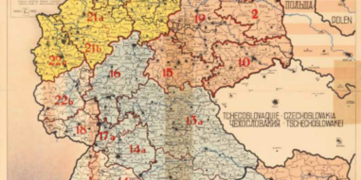
Germany divided and occupied The capitulation of Greater Germany brought about Allied occupation, extending its influence to Austria as well. In the aftermath of WW2, both countries, along with their respective capitals, are divided into zones of control under Soviet, American, British, and French rule. Germany ceases to govern itself to the extent that even…
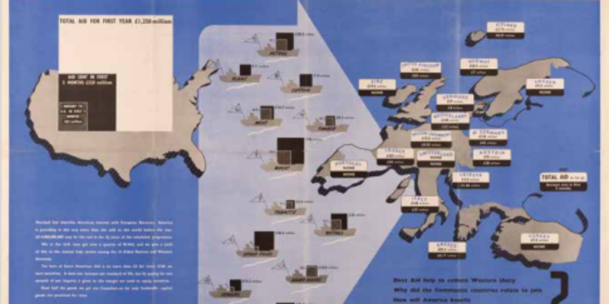
Marshall Plan as the start of Cold War Between 1948 and 1952, the United States allocated $13 billion (equivalent to over €150 billion today) to provide Europe with food supplies, industrial aid, and infrastructure development. This massive investment played a pivotal role in revitalising the European economy, effectively pulling it out of a state of…
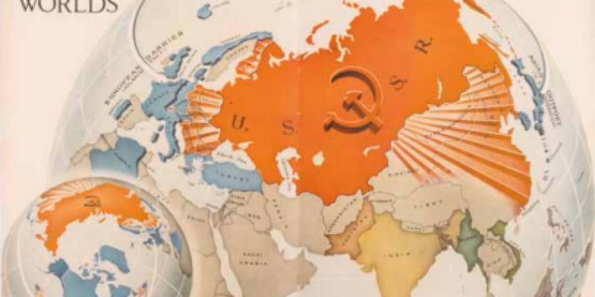
The World divided into red and blue The world is portrayed in shades of red and blue, with red symbolising the Soviet Union, and by extension, the colour of revolution. US propaganda enthusiastically adopts this colour scheme on this map, as it enhances the perceived threat and sheer magnitude of the continental Soviet empire. In…
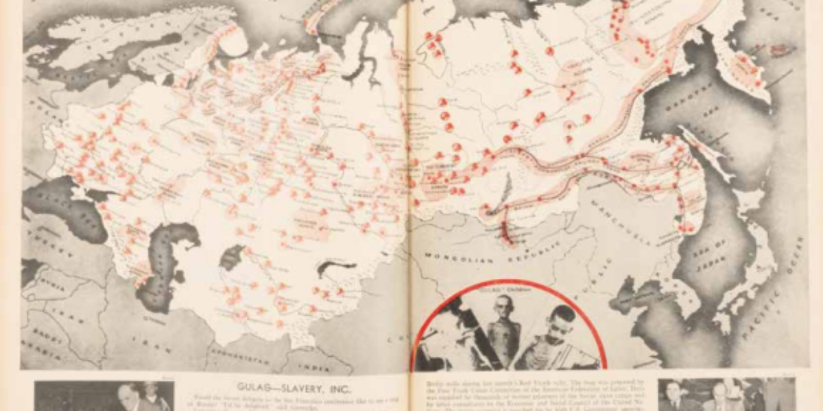
The Gulag, an archipelago of penal camps The term GULAG is the official abbreviation for the network of education and labour camps established in the Soviet Union from 1930. Under Stalin, this era of terror witnessed the condemnation of millions of Soviet citizens to long periods of confinement within these camps. Over time, defeated army…
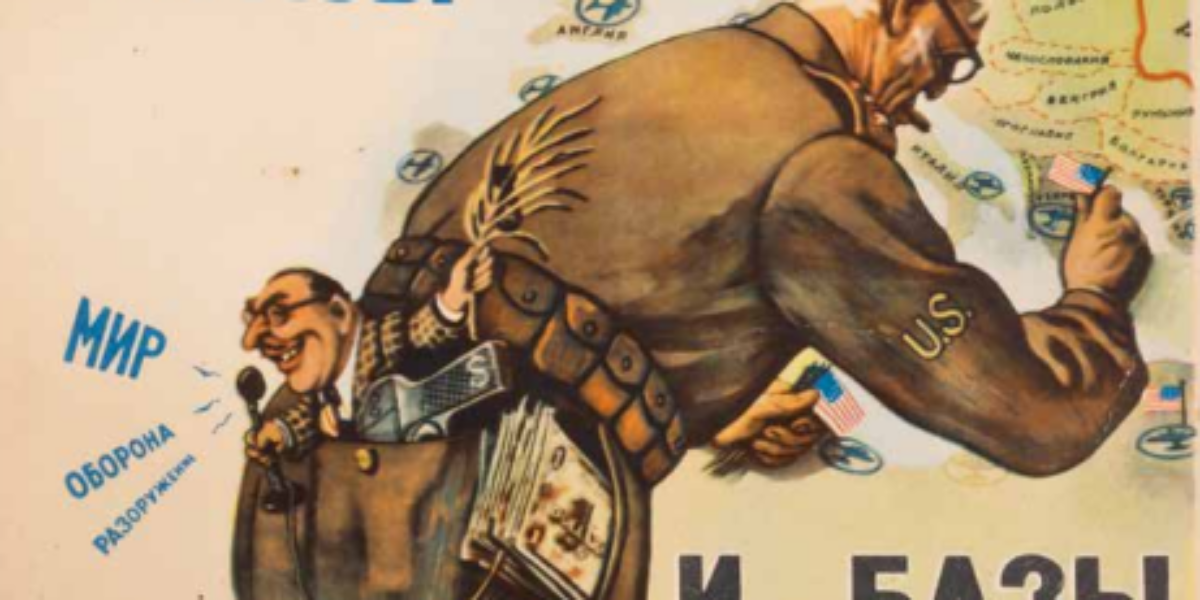
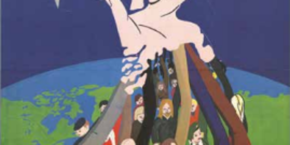
Satire as a weapon of propaganda While US radio broadcasts messages about world peace , defence, and disarmament (where ‘Мир/Mir’ signifies both ‘world’ and ‘peace’), the United States military is actively establishing military bases across Europe. The contrast between eloquent words and concrete actions did not go unnoticed by the Soviet Union in 1952, just…
Sheltering against nuclear attack From 1949, the deteriorating relations between the Western and Eastern blocs raised the spectre of a potentially nuclear world war. Amid these heightened tensions, plans to construct air raid shelters, such as the one depicted here in ‘s Hertogenbosch, were only sporadically realised, although its worth noting that the six air…
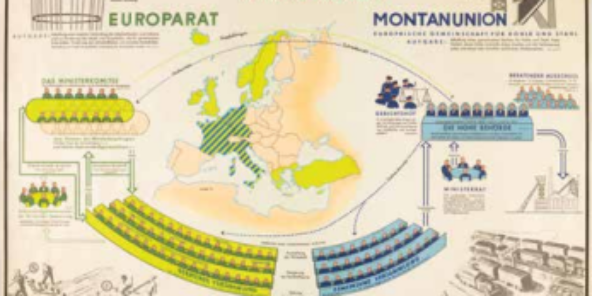
Beginnings of European integration The formation of the European Coal and Steel Community (ECSC) in 1952 was driven by a combination of political, economic, and military motives. One of the primary goals was to extricate West Germany from its post-war turmoil in order to prevent a recurrence of the retaliation witnessed after the Treaty of…
Beginnings of European bureaucracy In 1955, a political and economic alignment developed between the Europarat and the ECSC (Montanunion). Both entities boast supranational decision-making bodies, and the exercise of these powers falls under the control of parliament and the Court of Justice. Notably, the principle of the free movement of individuals had already been established…
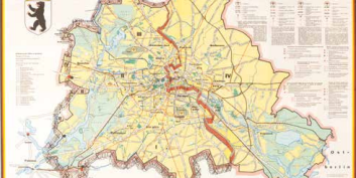
Berlin wall as Cold War symbol The Berlin Wall serves as a powerful symbol of the Cold War, occupying a prominent position on this schematic map of Berlin. This physical barrier marked the ‘final’ division between the western and eastern sectors of the city for its residents. In August 1961, this ‘wall of shame,’ (as…
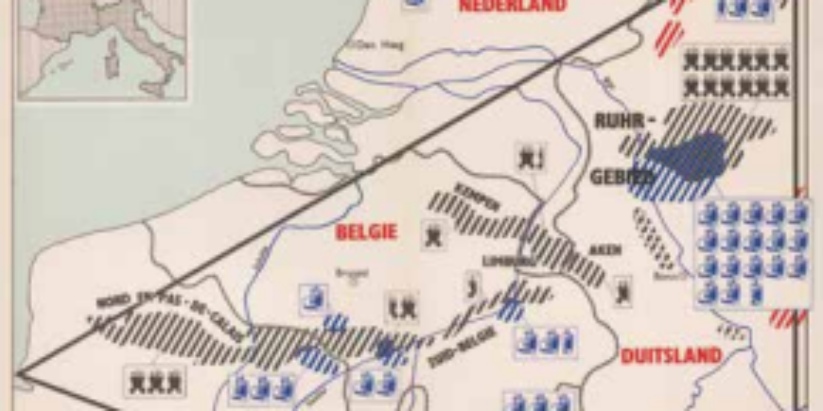
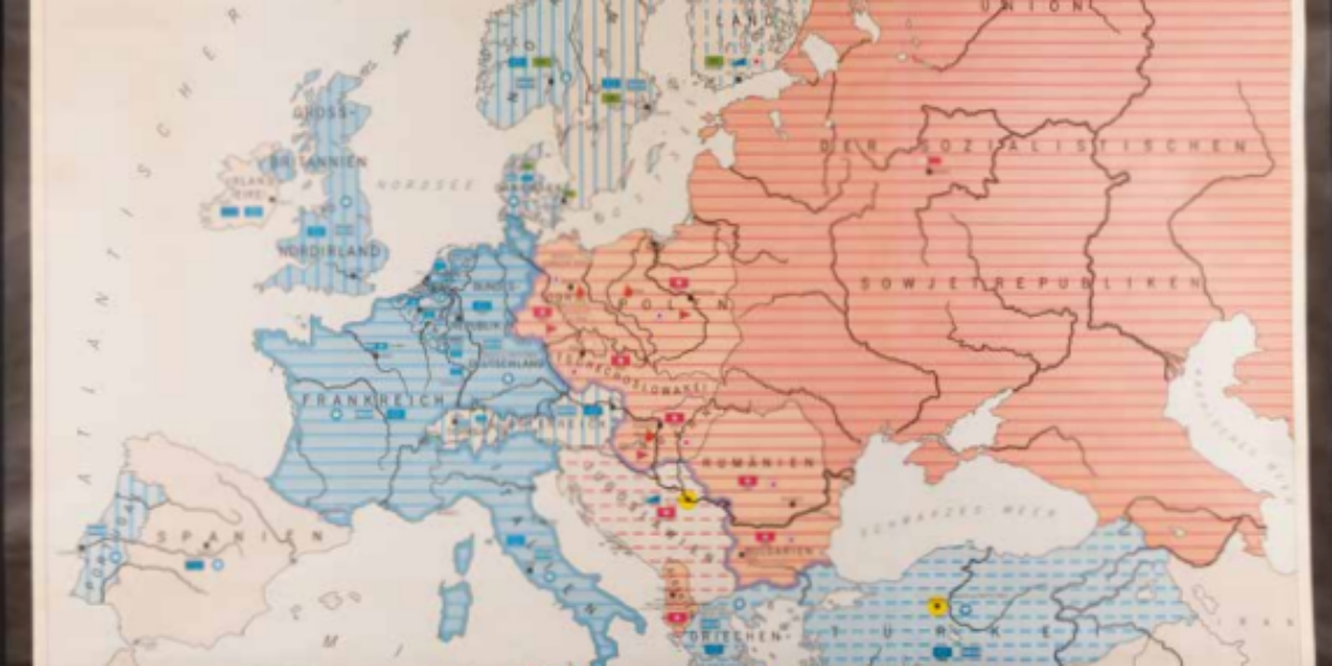
Europe divided by the Iron Curtain The primary division within Europe is delineated by the Iron Curtain, distinguishing the ‘capitalist’ West from the ‘communist’ East, symbolised by the colours blue and red on this map. This map starts with military cooperation, then political and finally economic.
Uprising in East Germany What began in the German Democratic Republic (GDR) as resistance to mandated increases in labour productivity among construction workers escalated into a broader workers’ and peasants’ revolt against the East German government within 24-hours. The resistance was violently suppressed by the Soviet Red Army in a matter of days. In response,…
Church opposition to nuclear weapons The Cold War reaches a distressing apex with the emergence of threats involving all-destructive neutron bombs. In the Netherlands, a fervent debate ensued over whether nuclear weapons should be stationed within its borders. Such a move carried the risk of provoking a nuclear attack from the Eastern bloc, in turn…
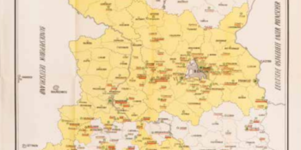
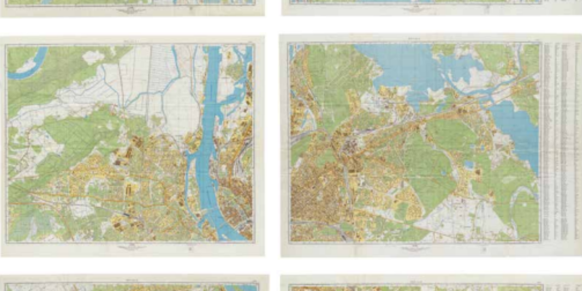
Aesthetics of military maps: Riga When this six-sheet map was printed in Leningrad, Riga was still a part of the Soviet Union. In contrast to maps of cities beyond the borders of the Soviet Union and its satellite states, this map boasts a higher degree of accuracy. It meticulously notes various details, including river flows,…
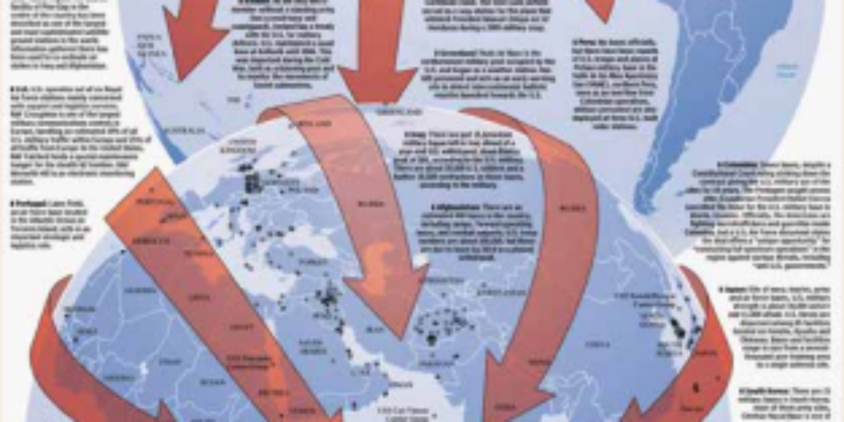
United States as (sole) world power For years there has been a prevailing perception among politicians, experts, and journalists that the era of the United States as a global superpower is waning. China has emerged as a prominent new global player, and the world is shifting towards a multipolar state system. As of now, the…
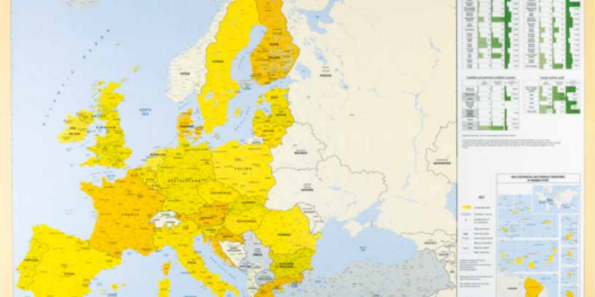
Subtle differences in Europe This map of the European Union from 2013 may appear quite ordinary, displaying an austere, objective, and institutional representation. It emphasises Estonia’s smallest province while deeming mountains insignificant. However, beneath this surface lies a subtle message: The map highlights the Union’s commitment to multilingualism by labelling all countries with their respective…
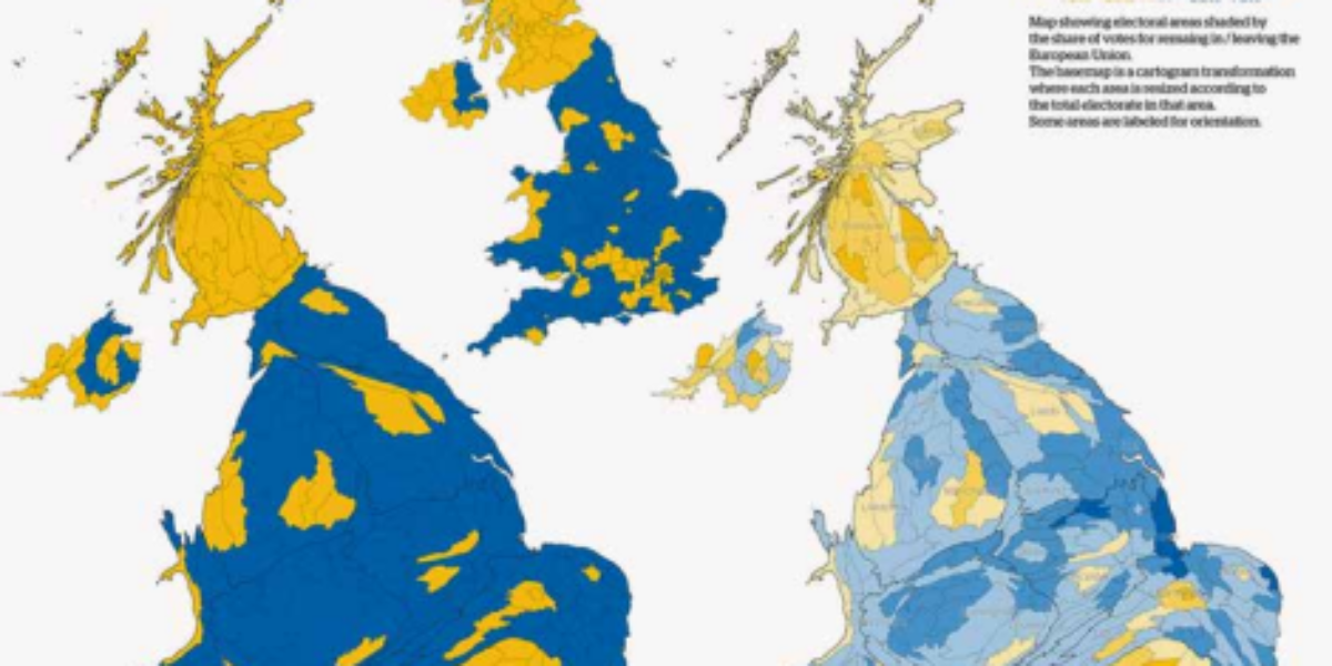
Brexit referendum divides Britons The map in the middle is a familiar geographical depiction of the UK. It suggests that the majority, especially in Scotland, leans towards remaining in the European Union, as indicated by the dominance of yellow over blue. However, the map on the left depicts electoral accuracy, while the one on the…
Nitrogen map causes farmers‘ revolt The question of how livestock farming in the Netherlands aligns with European environmental regulations has been an issue for decades. For many livestock farmers, a degree of reassurance could still be drawn from the 2017 Nitrate Map (21b), which depicts surface water quality. However, the June 2022 ‘nitrogen map’ that…
Loan Favan – TANEM FIUJA
Loan Favan was commissioned by Design Museum Den Bosch to create TANEM FIUJA, a series of jewellery and ornaments in which she speculates about the future of humanity.

The appearance of sex toys tells us a lot about how people felt about lust and gratification at a particular time. About the taboos that might still attach to them. And about the future of sex and the ideals of designers.

Your first kiss. You never forget it. No matter how sweet, sloppy or bad it was. After that, there’s no stopping you: on average you’ll spend 20,000 minutes of your life kissing.

Not happy with your body? Then do something about it. That seems to be the credo of our age, with its obsession with perfect bodies. But is the body really so perfectible?

The contents of Bouquet romantic novels might still leave something to the imagination, but not so their covers: this is the image of the ‘ideal man’. What does it say about our perceptions?

Seven Nights with the Sheikh, A Kiss in the Moonlight, An Heir for the King: the titles of romantic fiction in the world-famous Bouquet series have always appealed to the imagination. Guilty pleasures full of desire, temptation and happy endings are still extremely popular.

Butterflies in your stomach, unable to eat a thing, constantly daydreaming and checking your phone every five minutes to see if you’ve received a new message: falling in love is magical.


For centuries being a mum or dad was not a choice at all, simply how things were ‘supposed to be’. The way parenthood itself is viewed has also changed over the years.

Only three things are truly important in a marriage: you, your beloved and your love for each other. All the same, there are a lot more factors at play in the background.

In addition to their biological family, many people have one they’ve chosen for themselves: people you’re not related to, people who understand, help and love you.

See them whizzing across the city on their fast bikes: his a men’s model, hers a woman’s. Both wrapped in a puffer jacket and with matching trainers. The dreary ‘ANWB couple’ in trendy jackets.

We’ve all grown up with stories and clichés that have unconsciously influenced our image of love. Love, designed explores these stereotypes and shows how design guides the way we both seek and ‘consume’ love.

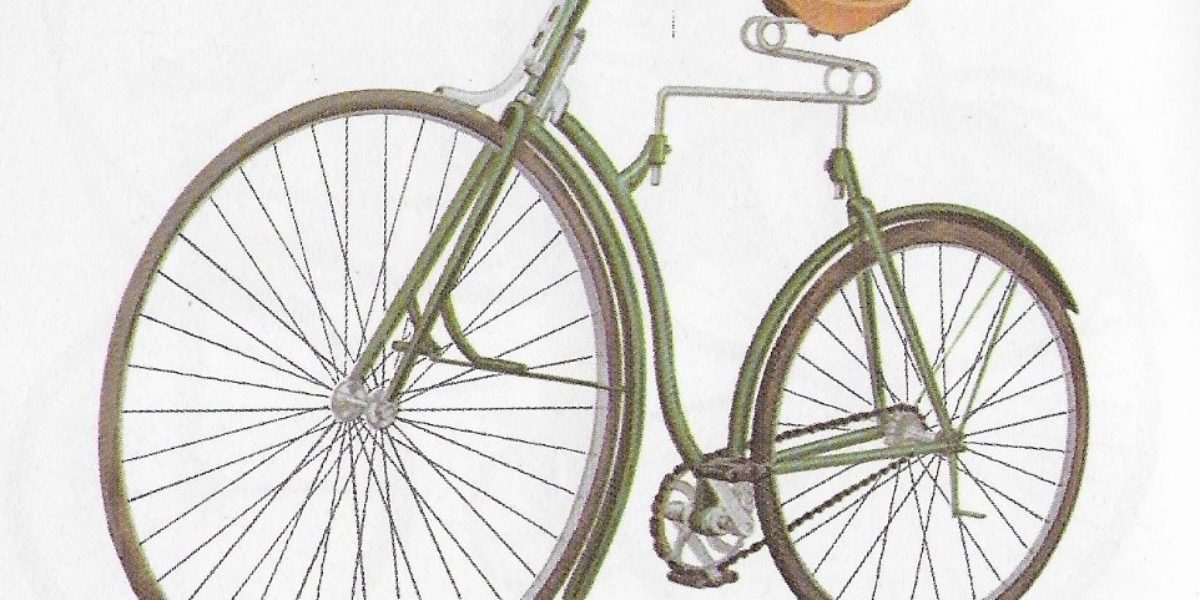
How did bikes evolve? Where did the Netherlands fit in around 1900? And what role did Fongers of Groningen play?
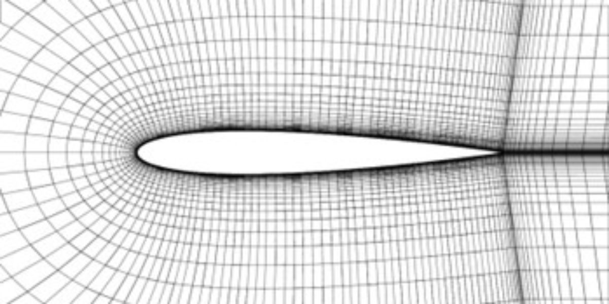
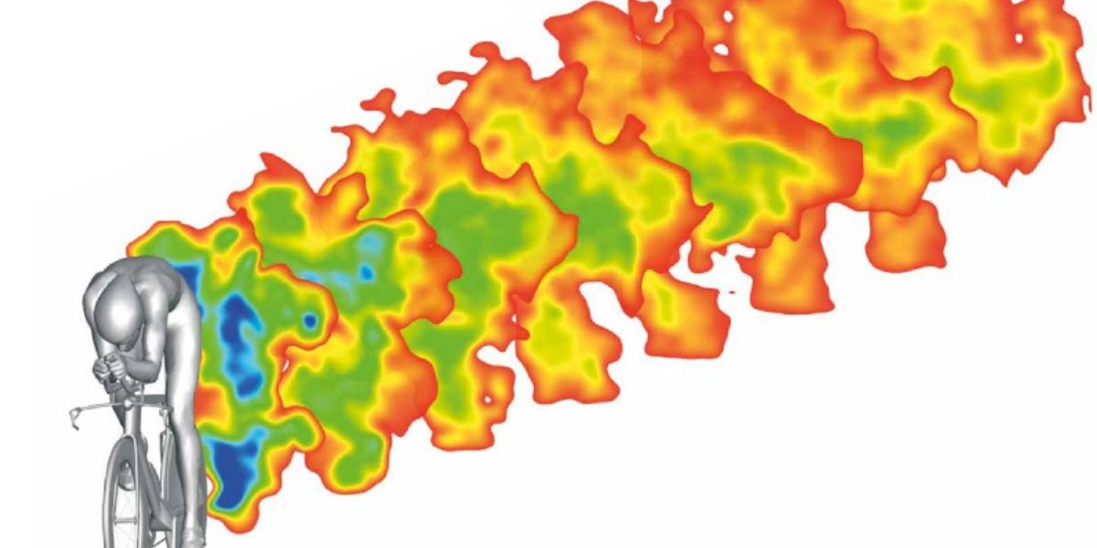
Annemiek Koers was responsible for the world’s most aerodynamic production car in 2022. She wrote an essay on calculating aerodynamic forces and what simulations are involved.
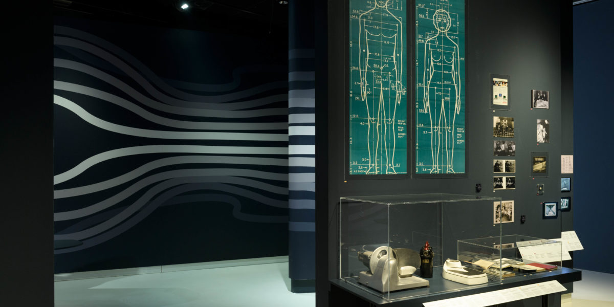
Christina Cogdell wrote a short essay for the Third Floor on eugenics as social streamlining.
Love, Designed
Love, Designed shows you how design guides the way we both seek and consume love. You’ll also meet the designers who speculate about alternatives to love’s many clichés. In short, the exhibition will open your eyes to how our image of love has been designed.

Mapping Modernity
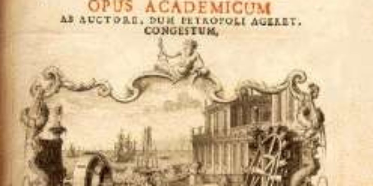
Mapping Modernity is an exhibition that tells the story of our world in 250 maps. Every map offers a glimpse into the mindset of those who commissioned it and the ways in which they sought to mould the world to suit them.
There are squids that, thanks to clever streamlining, can fly, but how do they do it?

Renowned tattoo artist Lecxi Doumer aka HOSTILITYANXIETY, one of the participating artists in Post-Tribal, will showcase their exceptional talent in real-time: tattooing guests of the museum on the tattoobed by Noah Cohen which was commissioned for the exhibition.
Why aren’t commercial flights getting faster? This video digs into the technological and environmental problems facing supersonic flight.

In 1926, architect Margarete Schütte-Lihotzky designed the first modern kitchen, a streamlined kitchen.
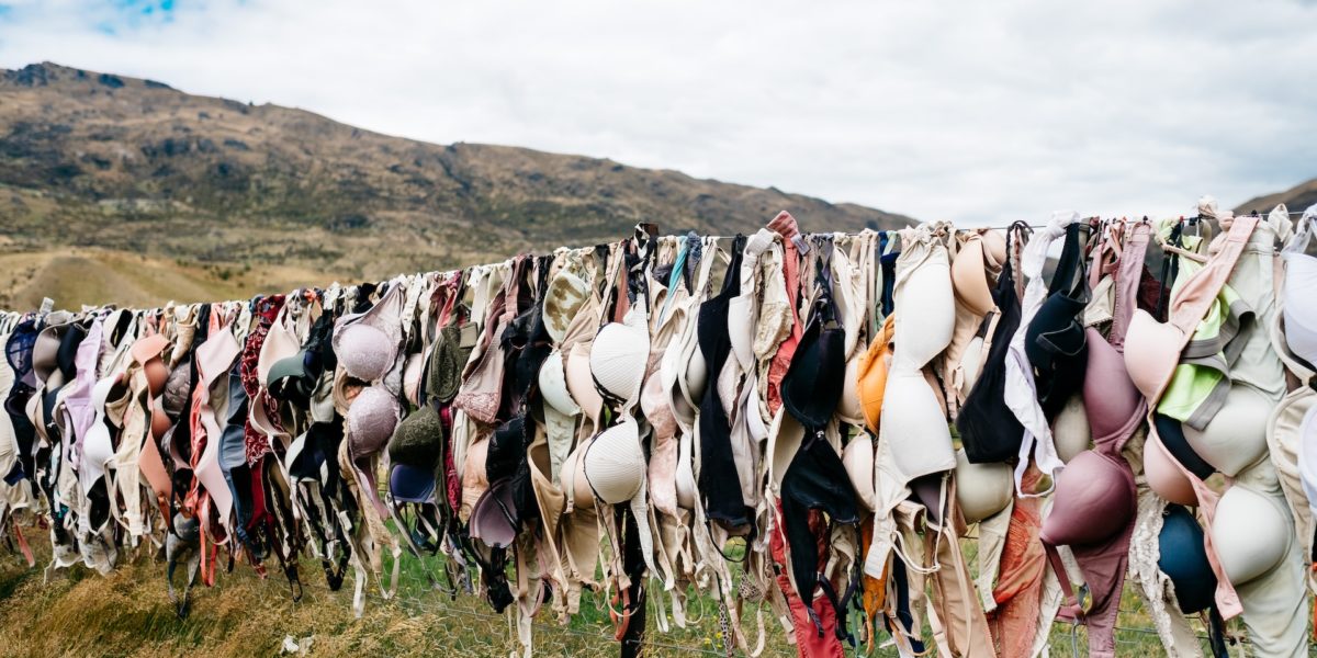
Lingerie has been around for hundreds of years, but it wasn’t until the 1920s that a standardised cup size system was invented that changed underwear forever

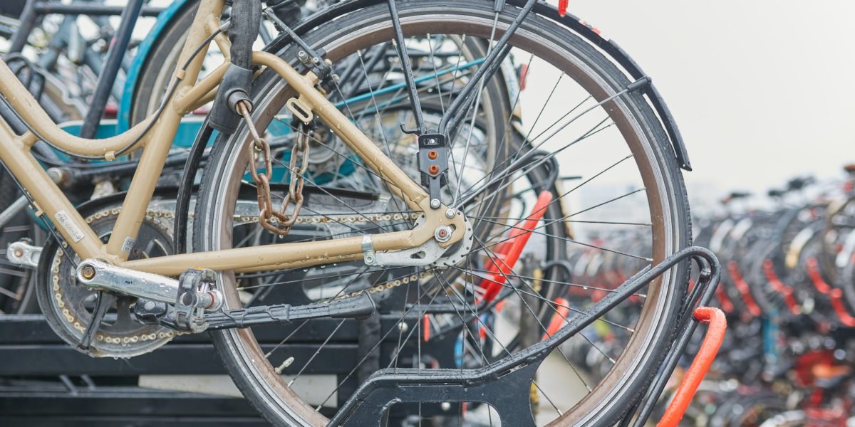
Bicycle paths have a major impact on cycling culture in the Netherlands and on what the Netherlands looks like. What is involved in designing a cycle path?
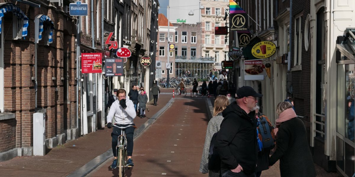

The Netherlands is known worldwide as a cycling country, but this didn’t happen overnight in the Netherlands either. For a while it even seemed that the car would win at the expense of the bicycle.
Design!
Our permanent Design! presentation can be found on the ground floor of Design Museum Den Bosch. Its 14 themes draw you into the world of design.

Design Prize 2023
Design Museum Den Bosch is proud to present the work of three talented Brabant designers short-listed for the Design Prize 2023: Manon van Hoeckel, Shahar Livne and Boey Wang.

Does it do anything for me?
Design Museum Den Bosch is showing a selection this summer from the extensive body of jewellery created by Hans Appenzeller (74), who has been active as a designer for over 54 years.

Much has been and continues to be written about streamlining, the design style as well as the scientific phenomenon. A selection of historical books by curator Tomas van den Heuvel.
Flow visualisations of four sports in which fluid mechanics is crucial: cycling, speed skating, skeleton and swimming.
Sigrid Calon – Everyday Tools
In the ceramics closet on the second floor of the museum, we present the recent acquisition of ‘Everyday Tools’ by Sigrid Calon.

In an age where our lives are inextricably tied up with new techniques and technologies, it’s important to pause from time to time to reflect on how these things are influencing both us and our society.


The location symbol is a genuine cultural phenomenon, but since the rise of social media, it’s also been part of who we are (or would like to be) as a person. Which is why we’re often oblivious to the dangers that it embodies.

To some people, a bike is just a simple form of transport. To others, cycling is a way of life.

For many people, the ring has a symbolic meaning. To them it’s much more than ‘portable wealth’.

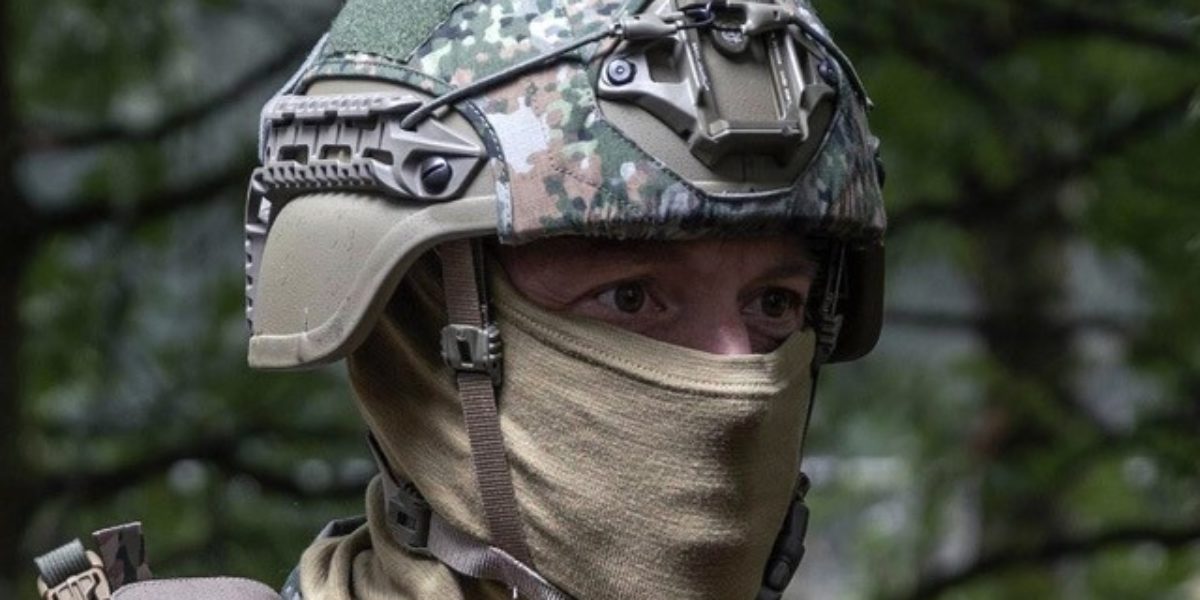
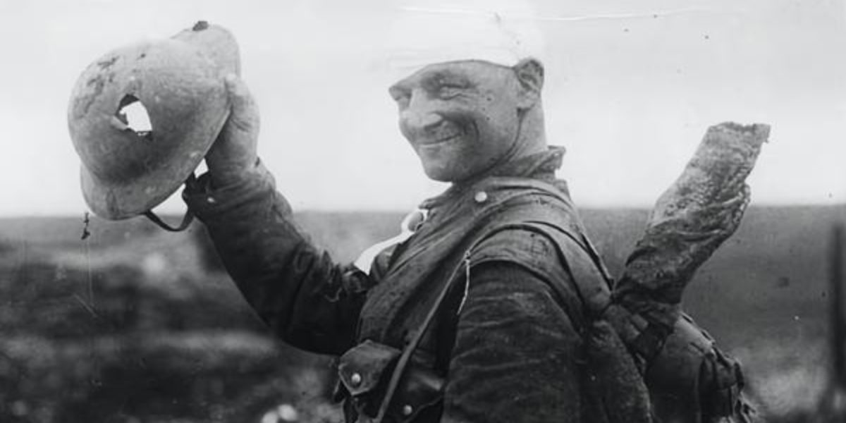
Modern military helmets bear little resemblance to the old, gleaming models with their crests swaying in the breeze. How did they develop? And what specifications does the Dutch Ministry of Defence impose for combat helmets today?
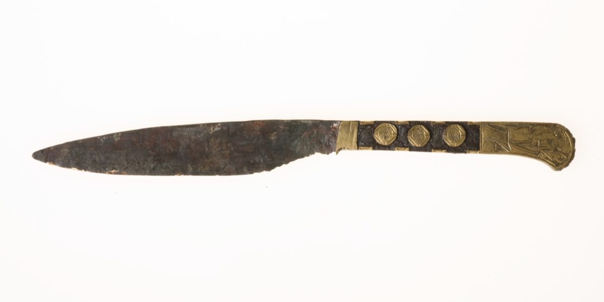
Nowadays a knife and a fork are laid out neatly on either side of your plate. Go back a few centuries, though, and there was no fork to be seen. Knives and forks originated in their own ways, a development illustrated by archaeological finds.
I have over a hundred houseplants in my house. So I couldn’t do without a watering can – it’s part of my standard equipment as a plant lover and gardener.

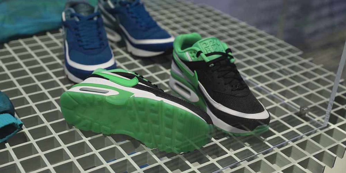
Someone in sneakers is a familiar scene, but still somewhat remarkable. Less than half a century ago, it would have been unthinkable to walk around in the street like that wearing sports shoes.

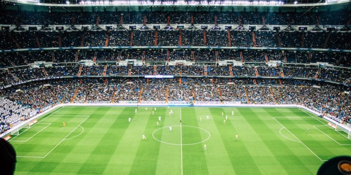
Sebas van Aert is a journalist and podcaster. He studied philosophy and played in NAC Breda’s youth football team. For the Third Floor, he wrote the article below. As soon as the whistle blows and the ball starts to move, the noise of the outside world fades away. Thoughts sink into the background, your head…
Hair removal, whether partial or full, goes back to time immemorial. But what impact has it had on us as human beings?

One moment a broad waist is fashionable, the next moment everyone wants a narrow waist. Sometimes underwear can help achieve that ideal shape.

‘As long as your hair is right’ sang the Dutch band Vulcano in 1983. A history of hairstyle.

Modern advertising presents us with ideas about gender and shaving that are mostly western and binary.

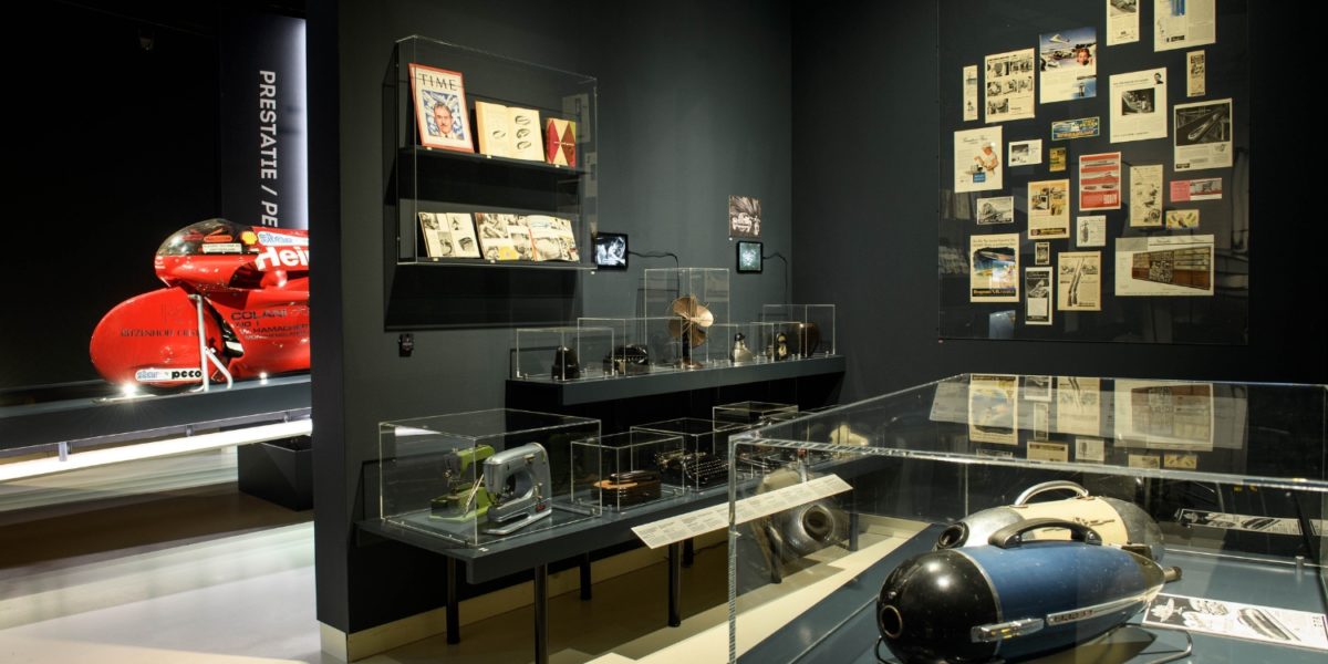
Today’s sports shoes are designed to keep improving your performance, which goes hand in hand with technical innovations and science.
Although your skull provides natural protection for your brain, the cranium cannot withstand a hard impact caused by an accident or a bullet.
As we travel, we are cut off from the world around us and often move so fast that we cannot even see who is driving next to us.

A dot, an arrow or a pin on a map on your smartphone: these are what you use nowadays to indicate where your body is located. But does anyone still remember the phone box?