‘Kill the Indian, save the man‘
This map illustrates the remaining tribal areas of Native Americans following a devastating history of epidemics, conflicts, and ethnic cleansing during the era of westward expansion in the United States. Aside from the remaining reservations, the map also highlights the 22 boarding schools for Native American children, denoted by red stars, each accompanied by its own cemetery(!). These boarding schools enforced strict policies of assimilation, requiring students to abandon their Indian names, and prohibiting the use of their native languages.
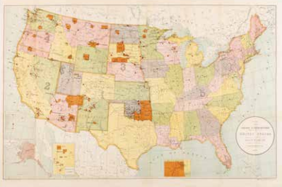
F. Leup, Map showing Indian Reservations within the limits of the United States, Washington 1905. Coll. S/T W.7x.305, 59 x 88.5 cm.