Threatening nuclear attack on Western Europe
This Polish-language training map for a large-scale attack from the east was made public in 2005 from a Polish state archive. The plan of attack involves throwing ‘tactical’ nuclear bombs at Western Europe, but not at the nuclear powers UK and France. Called ‘tactical’, those bombs are up to three times more powerful than those dropped on Japan in 1945. Western counterattacks are pencilled in, including with neutron bombs. Despite the five atomic bombs on the Netherlands, it takes into account supplies of NATO troops and material via Dutch and Belgian ports. It is only a detailed map for an imaginary offensive, but a war of conquest with nuclear weapons in Western Europe is apparently conceivable. Whether the Warsaw Pact could actually carry out such an attack is highly questionable.
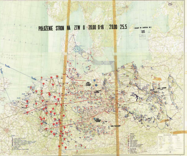
Germany divided and occupied The capitulation of Greater Germany brought about Allied occupation, extending its influence to Austria as well. In the aftermath of WW2, both countries, along with their respective capitals, are divided into zones of control under Soviet, American, British, and French rule. Germany ceases to govern itself to the extent that even…
Marshall Plan as the start of Cold War Between 1948 and 1952, the United States allocated $13 billion (equivalent to over €150 billion today) to provide Europe with food supplies, industrial aid, and infrastructure development. This massive investment played a pivotal role in revitalising the European economy, effectively pulling it out of a state of…
Berlin lifeline during land blockade This propaganda leaflet with cartographic infographics shows how an airlift negates the land blockade of West Berlin by the Soviets in 1948. The leaflet visualises the logistical operation required to provide people, food, fuel and building materials for 2.5 million West Berliners get to their destinations by plane. When this…
The World divided into red and blue The world is portrayed in shades of red and blue, with red symbolising the Soviet Union, and by extension, the colour of revolution. US propaganda enthusiastically adopts this colour scheme on this map, as it enhances the perceived threat and sheer magnitude of the continental Soviet empire. In…
The Gulag, an archipelago of penal camps The term GULAG is the official abbreviation for the network of education and labour camps established in the Soviet Union from 1930. Under Stalin, this era of terror witnessed the condemnation of millions of Soviet citizens to long periods of confinement within these camps. Over time, defeated army…
Satire as a weapon of propaganda While US radio broadcasts messages about world peace , defence, and disarmament (where ‘Мир/Mir’ signifies both ‘world’ and ‘peace’), the United States military is actively establishing military bases across Europe. The contrast between eloquent words and concrete actions did not go unnoticed by the Soviet Union in 1952, just…
Sheltering against nuclear attack From 1949, the deteriorating relations between the Western and Eastern blocs raised the spectre of a potentially nuclear world war. Amid these heightened tensions, plans to construct air raid shelters, such as the one depicted here in ‘s Hertogenbosch, were only sporadically realised, although its worth noting that the six air…
Beginnings of European integration The formation of the European Coal and Steel Community (ECSC) in 1952 was driven by a combination of political, economic, and military motives. One of the primary goals was to extricate West Germany from its post-war turmoil in order to prevent a recurrence of the retaliation witnessed after the Treaty of…
Beginnings of European bureaucracy In 1955, a political and economic alignment developed between the Europarat and the ECSC (Montanunion). Both entities boast supranational decision-making bodies, and the exercise of these powers falls under the control of parliament and the Court of Justice. Notably, the principle of the free movement of individuals had already been established…
Berlin wall as Cold War symbol The Berlin Wall serves as a powerful symbol of the Cold War, occupying a prominent position on this schematic map of Berlin. This physical barrier marked the ‘final’ division between the western and eastern sectors of the city for its residents. In August 1961, this ‘wall of shame,’ (as…
Europe divided by the Iron Curtain The primary division within Europe is delineated by the Iron Curtain, distinguishing the ‘capitalist’ West from the ‘communist’ East, symbolised by the colours blue and red on this map. This map starts with military cooperation, then political and finally economic.
Uprising in East Germany What began in the German Democratic Republic (GDR) as resistance to mandated increases in labour productivity among construction workers escalated into a broader workers’ and peasants’ revolt against the East German government within 24-hours. The resistance was violently suppressed by the Soviet Red Army in a matter of days. In response,…
Church opposition to nuclear weapons The Cold War reaches a distressing apex with the emergence of threats involving all-destructive neutron bombs. In the Netherlands, a fervent debate ensued over whether nuclear weapons should be stationed within its borders. Such a move carried the risk of provoking a nuclear attack from the Eastern bloc, in turn…
Soviet maps of Dutch cities Immediately after World War II, Stalin orders the world and all countries and relevant cities to be mapped. It is the largest cartographic project ever. Almost all larger Dutch cities are mapped in scales 1:10,000 or 1:25,000. The maps are still ‘secretno’, secret in Russia. Dordrecht and Maastricht are depicted…
Aesthetics of military maps: Riga When this six-sheet map was printed in Leningrad, Riga was still a part of the Soviet Union. In contrast to maps of cities beyond the borders of the Soviet Union and its satellite states, this map boasts a higher degree of accuracy. It meticulously notes various details, including river flows,…
United States as (sole) world power For years there has been a prevailing perception among politicians, experts, and journalists that the era of the United States as a global superpower is waning. China has emerged as a prominent new global player, and the world is shifting towards a multipolar state system. As of now, the…
Subtle differences in Europe This map of the European Union from 2013 may appear quite ordinary, displaying an austere, objective, and institutional representation. It emphasises Estonia’s smallest province while deeming mountains insignificant. However, beneath this surface lies a subtle message: The map highlights the Union’s commitment to multilingualism by labelling all countries with their respective…
Most commonly used cards: coins We pay less and less with it, but even our coins have a map. The five-euro cent shows a globe with Europe in the centre. The fifty-euro cent shows the European Union, regardless of whether countries have adopted the euro, and the two-euro coin shows all of Europe, including Norway…
Brexit referendum divides Britons The map in the middle is a familiar geographical depiction of the UK. It suggests that the majority, especially in Scotland, leans towards remaining in the European Union, as indicated by the dominance of yellow over blue. However, the map on the left depicts electoral accuracy, while the one on the…
Nitrogen map causes farmers‘ revolt The question of how livestock farming in the Netherlands aligns with European environmental regulations has been an issue for decades. For many livestock farmers, a degree of reassurance could still be drawn from the 2017 Nitrate Map (21b), which depicts surface water quality. However, the June 2022 ‘nitrogen map’ that…