Return of enslaved people to West Africa
This map of West Africa depicts in colours the routes of four expeditions conducted between 1794 and 1822, which aimed to explore the interior of Sierra Leone and a portion of Guinea. Two of the explorers were responsible for creating this map. Importantly, after the abolition of slavery, the coastal region served as the destination for freed Africans returning from North America and the British Antilles.
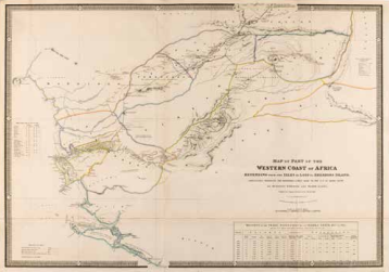
Surgeon O'Bierne and Major Laing, Map of Part of the Western Coast of Africa, Extending from the Isles de Loss to Sherboro Island, Particulary Exhibiting the discoveries lately made to the N.E. of Sierra Leone, London 1843. Coll. S/T U.6y.21, 67.5 x 97.5 cm.