Newspaper map as informational propaganda
As the tide of the war turns, the American home front receives increasingly enthusiastic maps. Charles Owens contributes maps on a weekly basis to American newspapers. His maps exhibit a style reminiscent of Hollywood movies and comic books. They feature a unique perspective with the earth depicted in a convex manner, providing a satellite-like view ahead of its time. The maps also include German air landings and attacks on transport ships, and bombings are illustrated with white clouds for dramatic effect.
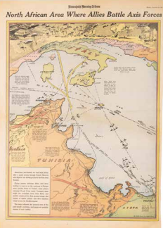
C. Owens, North African Area Where Allies Battle Axis Forces, Minneapolis 1942, from: Minneapolis Morning Tribune, December 22, 1942, p. 18, reprinted from the Los Angeles Times. Coll. S/T W.2n.22, 58 x 41.5 cm.
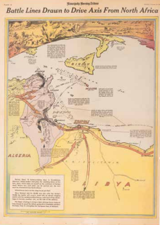
(C. Owens), Battle Lines Drawn to Drive Axis From North Africa, Minneapolis 1943, from: Minneapolis Morning Tribune, February 18, 1943, p. 16. Coll. S/T W.2n.23, 58 x 41.5 cm.