The Rhine River basin
This elevation map of the Rhine River basin still shows national boundaries, but from a water management perspective, we need to look at the entire river basin. The Netherlands is heavily dependent on Rhine water, when it comes to quantity as well as quality. The melting of Swiss glaciers affects the availability of water in summer: all too rapidly, the Rhine is turning into a ‘rain river’ fed only by direct precipitation. The flow rate is so low that scarcity is an increasingly frequent occurrence in the water-rich Netherlands. Ships’ cargo capacity is diminished, power plants are shut down due to lack of cooling water, and salty water penetrates deep into the country via the river mouth. Furthermore, the lower the water level in the river, the higher the concentration of pollution: as a result, our supply of drinking water is threatened (see map 11). That means saving and cleaning water is called for.
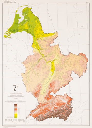
Commission Internationale de l'Hydrologie du Bassin du Rhin / Internationale Kommission für die Hydrologie des Rheingebietes, (International Commission on the Hydrology of the Rhine River Basin). Altitudes / Hohenschichten, from: Le Bassin du Rhin / Das Rheingebiet (The Rhine Basin), Bâle/Basel 1977. Coll. S/T P.223, 59.5 x 42.5 cm.