From savages to enlighten
This moral and political map is often reprinted from 1821 onwards, including in the School Atlas by Woodbridge and unnamed co-author Emma Willard. Geographically for schoolchildren and the general public, the atlas depicts Western superiority through a modern approach to the process of civilisation. The development from savages, through barbarians, semi-civilised and civilised to enlightened progresses visually from dark grey to radiant light. All American Indian tribes are depicted as savages, except the barbaric Pueblo Indians. It is not the form of government (defined from chieftaincy to republic, with the Netherlands being a constitutional monarchy), but Christianity that largely defines civilisation. Large parts of Asia and almost the entire ‘Muslim’ world are only semi-civilised. Christian Haiti of the ‘free Africans’ is drawn as civilised, while uncolonised ‘pagan’ Sub-Saharan Africa is seen as barbaric.
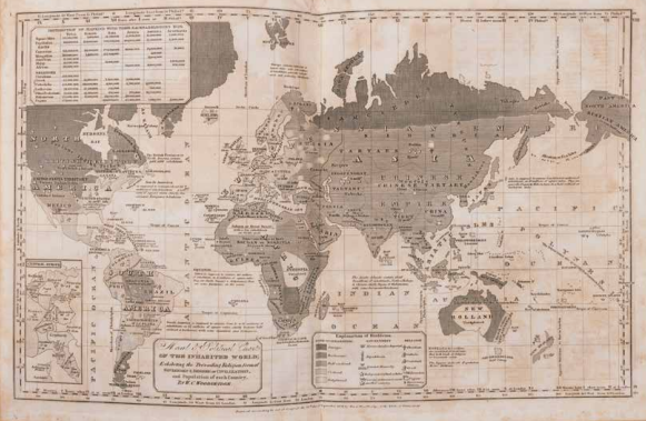
W. C. Woodbridge, Moral and Political Chart of the inhabituated World, in: Modern Atlas on a new plan, to accompany the system of Universal Geography, sixth edition, Hartford 1835. Coll. S/T D.33, 30.5 x 48.5 cm.