Leopold’s reign of terror in Congo
In 1885, the Berlin Conference designated Congo Free State (an area 76 times the size of Belgium!) as the personal possession of King Leopold II. The map uses colours to divide the country into various concession areas. Private companies exploit raw materials here, especially rubber for the transport industry, disregarding communal lands. Leopold’s private army of white officers and black soldiers runs a veritable reign of terror with hostage-taking and rape,burning down villages, chopping off hands and beheading indigenous leaders. Under Leopold, the black population of Congo Free State drops by millions. The map also shows the division into Roman Catholic mission areas and incipient dioceses (the ‘apostolic prefectures’ and ‘vicariates’). Missionaries do not want to openly offend the king but do try to prevent ‘abuses’. In response to fierce international criticism, Leopold sends a ‘commission of enquiry’, whose route is marked on the map up to Stanleyville. In 1908, he has to hand over his private colony to the Belgian state.
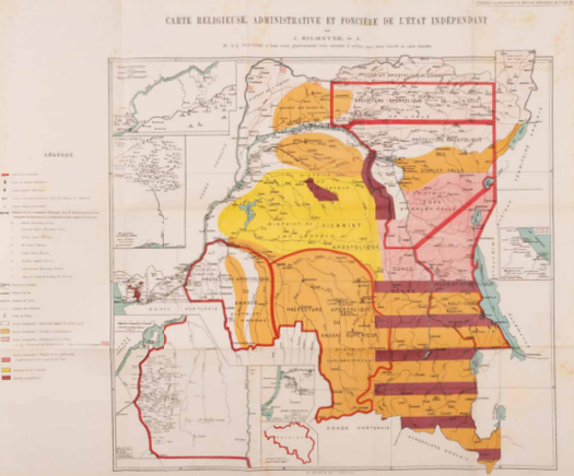
J. Bilmeyer S.J., Carte Religieuse, Administrative et Foncière de l'État Indépendant, In: Le Mouvement des Missions Catholiques au Congo, Bulletin de la Societé antiesclavagiste de Belgique et de l'Oeuvre des Missions Catholiques au Congo, 18e Année No 6, Bruxelles 1906. Coll. S/T W.6d.28, 52 x 80 cm.