The first regional plan: IJsselmonde
Commissioned by private Rotterdam investors, architectural firm Grandpré Molière, Verhagen & Kok develops an expansion plan for Rotterdam’s south bank in 1921. The Netherlands’ first ‘regional plan’ includes the entire IJsselmonde island. Space is needed for intensive industrialisation and working-class districts, as well as for heavy infrastructure, greenery, and recreational areas. Inter-city connections remain focused on the centres, although the plan already includes the Maastunnel (completed in 1942) and Van Brienenoord Bridge (built in 1965). The plan targets a gradually more widely dispersed built-up area to the outside and a smooth transition to open, green-fringed recreational areas, with no apparent consideration of agricultural function. Although Rotterdam has no right to make decisions about the rest of the island, the plan is decisive for spatial planning of the entire area. This leads to building up virtually all of IJsselmonde, with suburban sprawl, disjointed villages, and a great deal of intersecting infrastructure. The beautifully designed plan features outlined reservations for future development and, as a result, remains relevant for a long time.
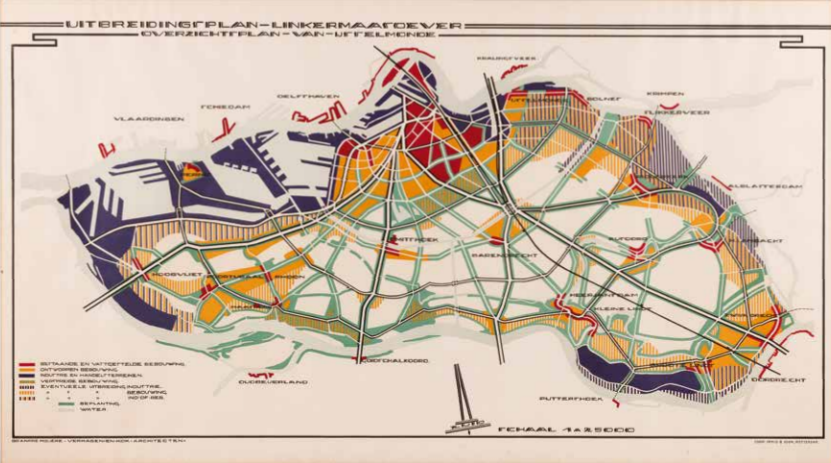
Horse-drawn tram of Amsterdam In congruence with the commissioning of the Amsterdam-Haarlem railway line in 1839, a private company was granted a municipal concession to operate an ‘omnibus’, a horse-drawn bus in the municipality of Amsterdam. This initiative marks the advent of modern urban logistics. We will have to wait only another 30 years for…
Cholera in Amsterdam The Netherlands experienced its final significant cholera epidemic during the years 1866-67, with the disease spreading rapidly in Amsterdam. It was during this period that maps assumed a pivotal role in charting and discovering the patterns of transmission, heralding the advent of spatial epidemiology. In 1854, in London, the scientist Dr. John…
Spectacular growth of Amsterdam Starting in the mid-19th century, Amsterdam experienced a remarkable period of growth. This cadastral area map, once the possession of Mayor d’Ailly from 1946 to 1956, illustrates the city’s transformation beyond the Singelgracht, including space for new harbors, a cattle market, a slaughterhouse, cemeteries and parks.
Amsterdam and resistance hotspot the Jordaan In the early 17th century, the Jordaan district found itself enveloped by Amsterdam as the city underwent urban expansion. This 1920 report takes stock of the (poor) housing quality, the density of habitation and the (widespread) absence of water pipes and toilets. This report strongly conveyed the enormity of…
Garden city in Amsterdam Rotterdam’s city architect, Willem Witteveen, develops a vision of ‘beautiful order’ for the westward expansion of Amsterdam, which he publishes in the pages of ‘Volkshuisvesting en Stedebouw,’ the trade magazine of the interwar period. The Art Deco inspired map reveals a plan for an expansive area that was never implemented.
Amsterdam as a functional city Urban designer Cornelis van Eesteren has a significant influence on urban development in the Netherlands. In 1929, he became Director of Amsterdam’s Public Works Department, where he developed the Algemeen Uitbreidingsplan (General Expansion Plan) with Th. van Lohuizen. His approach to designing and drawing is strongly influenced by the ‘Congrès…
‘s Gravenhage embarks on modernisation In 1858, the administrative capital of the Netherlands had already witnessed a twofold increase in its population compared to a century prior. This cadastral map of The Hague shows little sign of modern urban development, though it does include a few remarkable details:. the roofs of the city’s churches are…
‘s Gravenhage as an early shopping city This tourist map offers a neat display of official buildings, but what is more captivating is the kaleidoscope array of business facades adorning the map’s border. These businesses, as depicted, likely helped in the creation of this early advertising map. This map captures a moment in history when…
Berlage’s plan for ‘s Gravenhage Architect and urban planner Hein Berlage drew numerous expansion plans for several Dutch cities, including Groningen, Utrecht, and Amsterdam(-South). However, it was his expansion plan for The Hague that stands as his most far-reaching endeavor. Although not everything was implemented, this expansion plan determined the spatial development direction of The…
Eindhoven as a collection of villages Architect Joseph Cuypers from Amsterdam and Eindhoven’s city architect, Louis Kooken, collaborated to design the first General Expansion Plan for ‘Greater Eindhoven.’ As the name of the map suggests, the annexation of neighboring villages occurred before the plan’s conception, with its implementation not commencing until after 1920. The plan…
Apeldoorn: the largest village in the Netherlands The 1901 Housing Act stipulates that all municipalities larger than ten thousand inhabitants must draw up an expansion plan. Apeldoorn responded by creating a global plan in 1910. Transforming from a dormant royal residence, Apeldoorn grows into ‘the largest village in the Netherlands.’
Waterline hinders expansion of Utrecht Hein Berlage is commissioned to design an expansion plan for Utrecht, together with director of Public Works L.N. Holsboer. At the time, Berlage has become renowned as an acclaimed urban planner. Utrecht is located near the Nieuwe Hollandse Waterlinie, an 85-kilometre stretch of forts, castles, and strongholds. The duo takes…
Groningen also needs to grow This city plan for Groningen, by H.P.J. Schut, the director of municipal works, and his ‘advisor’ Berlage, is a true structural blueprint focused on infrastructure and building blocks. Nearly a century later, this plan still serves as a reference point, as demonstrated in 2020 when designers for the new Oosterparkkwartier…
London modernises Amid the status of London as a world capital, a drastic spatial initiative is being planned: the development of the West India Dock, indicated on the right side of the map. These docks are set to mark a significant step in the modernization of London’s bustling port. The docks will herald the modernisation…
London prays, learns and drinks Around 1900, the social researcher and magnate Charles Booth created his iconic ‘poverty maps’ of London. In the culmination of his project, he charted the positions of churches, schools, off-licences, and pubs, effectively visualising the spatial interplay between virtue and alcohol. Surprisingly, his findings dispelled the notion that poverty is…
‘Potato’ Map of London During World War II, urban planners John Forshaw and Patrick Abercrombie outlined a vision for London’s post-war spatial development. Their plan envisioned neighbourhoods as a collection of self-sufficient islands, each with its own character, separated by green spaces and infrastructure. Little has come of this due to spectacular growth in…
Paris: modernity versus revolution On the initiative of Napoleon III, France’s last monarch, Georges-Eugène Hausmann, capital prefect, modernises the Paris urban structure and street layout. Napoleon III personally sketches the designs for this. At the time of this map’s publication (1867), the work is largely complete. The city is seen as a living organism where…
Modern Paris underground The Paris of 1900 wasn’t just characterized by its endless streets; it also boasted a thousand-kilometer-long sewage system. This unique underground Parisian network, featuring colossal pipes, has transformed into a present-day tourist attraction. Despite the French inclination toward state intervention and centralization, the construction of the Paris sewer system occurred relatively…
Premodern Berlin In the early 19th century, Berlin was a relatively compact European capital city, housing a mere 175,000 residents, making it even smaller than Amsterdam. What is particularly recognisable is the mediaeval core and a Renaissance city, seemingly fused together without real cohesion.
Building regulations against sprawl in Berlin At the beginning of the 20th century, Berlin transformed into a bustling ‘boomtown,’ experiencing an expansive growth. The metropolitan area now has three million inhabitants, propelling it to the status of the fourth-largest city behind London, New York, and Paris. This rapid expansion, characterised by chaotic growth, pushed the…
Moscow: developing power centre In 1712, Tsar Peter designated St. Petersburg as the capital of Russia. Yet Moscow retains its significance as an important city and a symbol of Russia’s eastern-continental focus. Emerging from the Kremlin, which served as the initial city wall, Moscow evolved into the political epicentre of the Muscovy region, eventually renamed…
Moscow, Europe’s largest metropolis In 2012, predating Putin’s re-election as Russia’s president, the internationally renowned Rotterdam-based design studio OMA received an invitation from Moscow city authorities to participate in a design competition involving ten companies. The objective was to influence the spatial development of Greater Moscow. OMA’s vision championed a multipolar approach to expanding Europe’s…
Cairo as a pre-modern city The Description de l’Egypte, a monumental collection of richly illustrated observations and inquiries, produced by 160 scholars and engineers during the Napoleonic occupation of Egypt from 1798 to 1801. Among its treasures is a captivating full-page etching portraying Cairo facing west as it stood around the year 1800, when the…
Cairo as a world metropolis Greater Cairo is the second-largest metropolis on the African continent, following Lagos in Nigeria, and is the largest urban area in the Middle East. In 2018, this sprawling capital was home to 22 million inhabitants, approximately 70 times more than in 1800. Both cutouts depict the entire region surrounding Cairo,…
Tokyo just before modernisation This ‘Fuku painted map of Tokyo,’ originates from the 3rd year of Emperor Meiji’s reign in 1855. This particular version is a partially supplemented reprint from 1879. The map already holds a resemblance to European city maps of the era, featuring a flat surface, defined streets, numbered buildings, and the highlighting…
Tokyo as modern design Even when using the smartest design methods to schematise underground and overhead rail networks, representing rail lines of the world’s largest metropolises results in a practically illegible jumble of lines. This is a schematic map of almost all public heavy rail transport in the Greater Tokyo area: a mega-metropolis of 35…