Veluwezoom National Park The ‘Veluwezoom’ becomes the Netherlands’ first national park in 1930. Natuurmonumenten aims not only to protect endangered areas but also to make visitors know and love nature better. By 1939, there are already ninety state nature monuments spread throughout the Netherlands.
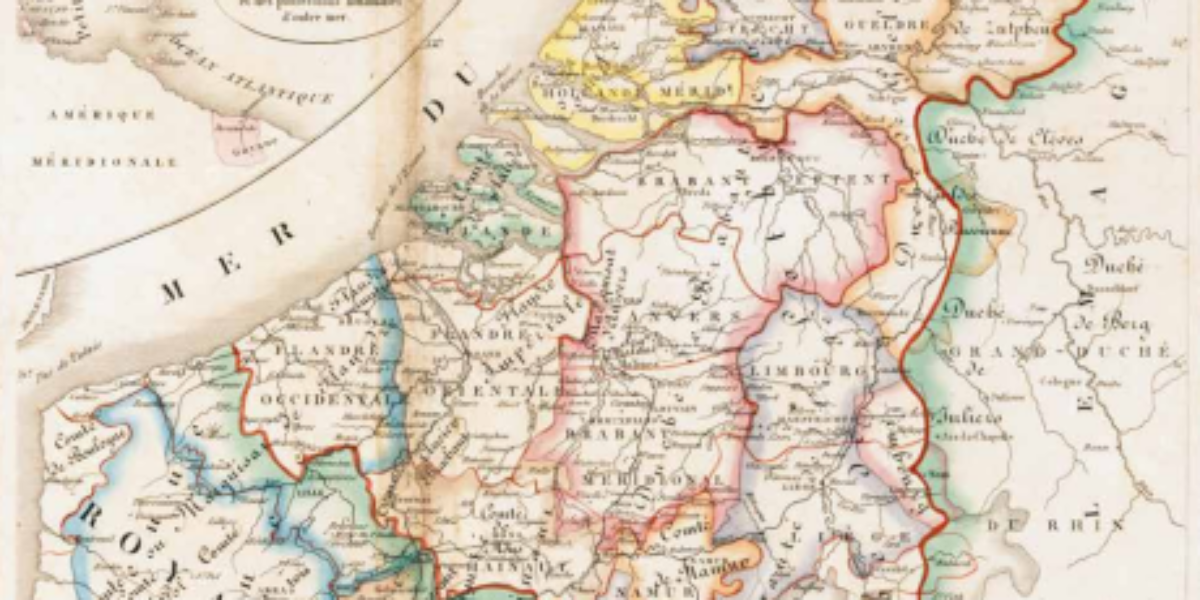
Belgium and the Netherlands For centuries, ‘the Netherlands’ and ‘the Low Countries’ have served as Germanic equivalents for the Romanesque ‘Belgica’ or ‘Belgique’ and ‘Pays-Bas.’ In this 1837 map, which is identical to the 1827 version, this linguistic detail remains intact. However, there is a small inset map at the top left that acknowledges the…
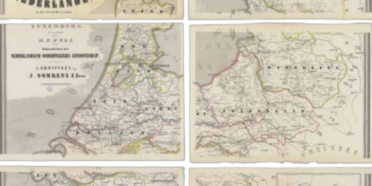
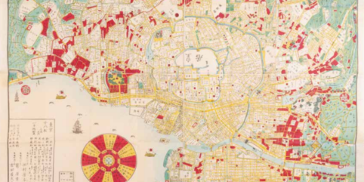
Wall map of the Kingdom During the mid-19th century, the wall map made its appearance in the classroom. These hand-coloured maps depict 11 provinces, complete with the provincial and district capitals, smaller towns, villages, hamlets, as well as the country’s network of waterways and railways. The map also displays the Dutch colonies and the Grand…
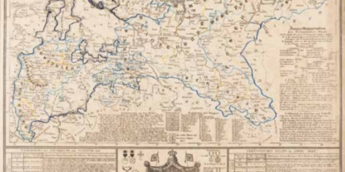
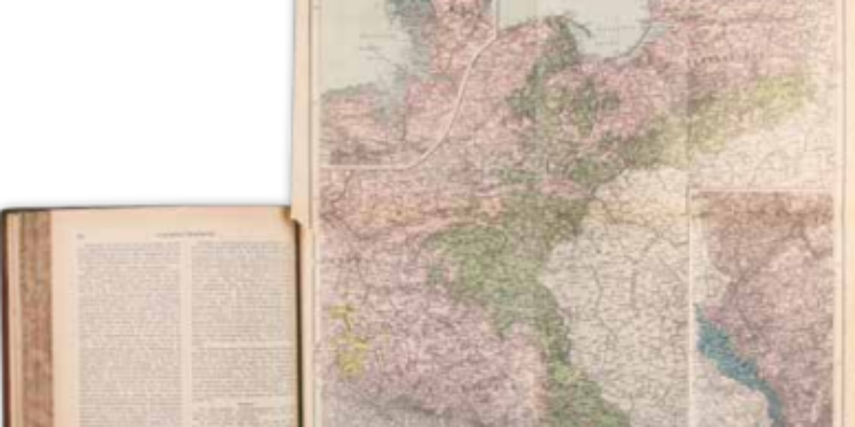
Kingdom of Prussia Framed within light blue borders, this survey map featured in the Atlas des Königreichs Preussen provides a representation of the Prussian Empire following the Congress of Vienna in 1815. This map illustrates how Prussia extended its territorial control over large portions of western Germany during this period. To avoid any potential confusion,…
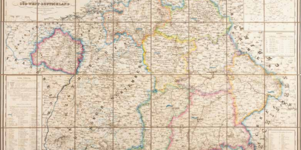
Kingdom of Bavaria This modern statistical map shows highlights of various districts, along with their respective administrative and military capitals. However, it places the capital Munich at the forefront by giving it the most authority symbols. In doing so, this practical map promotes Bavarians to identify with the new kingdom, underscoring the modern administrative structure…
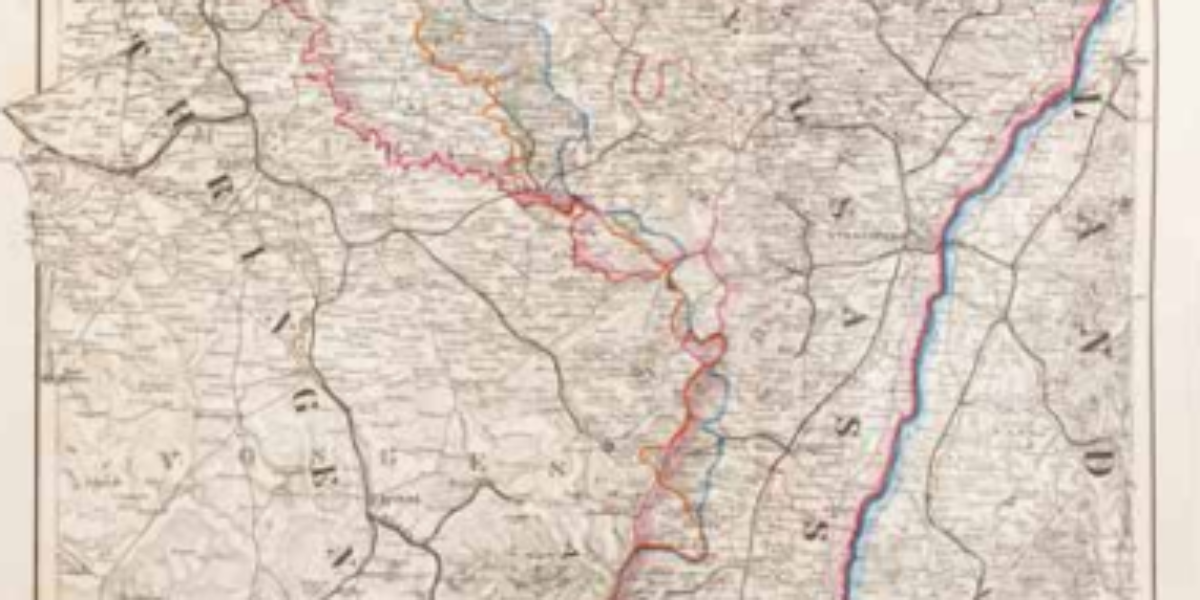
German-French language border in Alsace This map demarcates regions where German or French is the predominant mother tongue while also highlighting mixed intermediate areas. The map serves to legitimize the annexation of Alsace by Bismarck and the German states on this basis of ‘linguistic human rights’.
Office map of the German Empire This wall map, consisting of sixteen free supplements to Henzes Illustriertem Anzeiger, offers a portrayal of the German Empire as it was established within the hall of mirrors at Versailles in January 1871. However, the map also caters to liberal circles by placing emphasis on industry and trade.
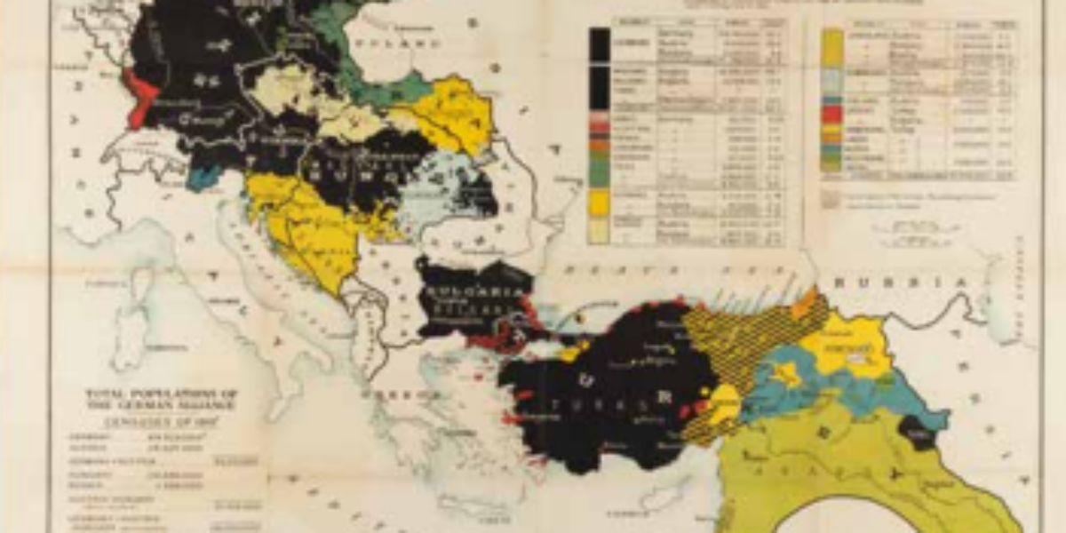
Strange tribes in the German Empire The geographer and cartographer Paul Langhans is recognized as a pioneer in the discipline of ethnocentric geopolitics. This map differentiates regions by the dominant language spoken, with a secondary distinction marking different religions, presenting Protestant areas in a bright color and Catholic regions in a grayish one. Non-German-speaking majorities,…
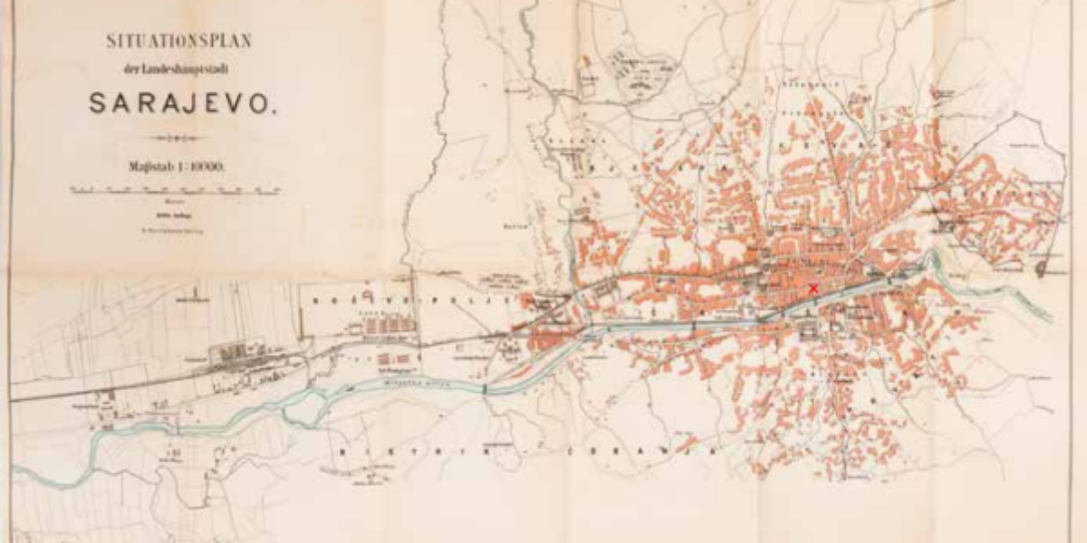
Map of Sarajevo World War I marked the end of a relatively stable period in Europe. This map of Sarajevo features a prominent red X, marking the precise location where Bosnian Serb Gavrilo Princip carried out his fateful assassination of Archduke Franz Ferdinand and his wife Sophie on June 28, 1914. A month later, Austria-Hungary…
Belgium in 1914 This military survey map, accompanied by annotations detailing the movements of advancing German troops, highlights the military significance of the forts surrounding Antwerp, Namur, and Liège in Belgium. It reflects a pivotal moment where Belgium is defeated with the exception of the Westhoek region near the Yser River.

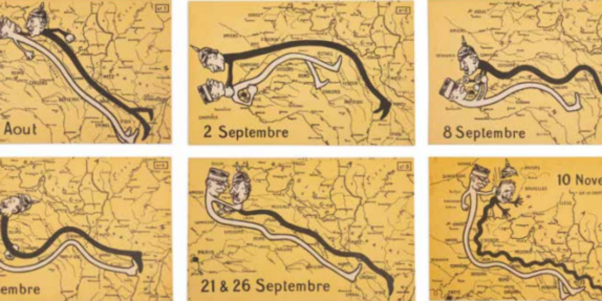
Stalling motion war These postcards offer a perspective on the elongation of the front and the stalemate that characterized the German War of Movement in northern France in 1914. In a somewhat satirical manner, these postcards depict Kaiser Wilhelm and French commander-in-chief Joffre engaging in fistfights to represent the various battles.
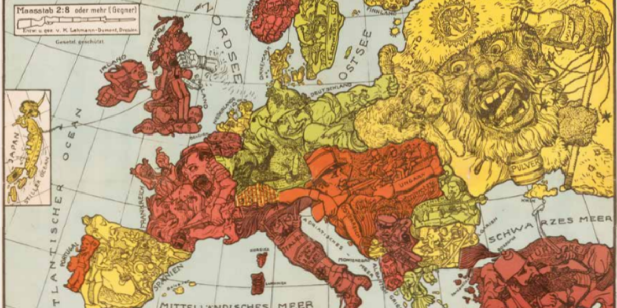
German propaganda card 1914 This intricate German propaganda map, produced in late 1914, offers a lighthearted and caricatured depiction of the early stages of World War I in Europe. However, the amusement derived from such cartoon maps would soon fade.
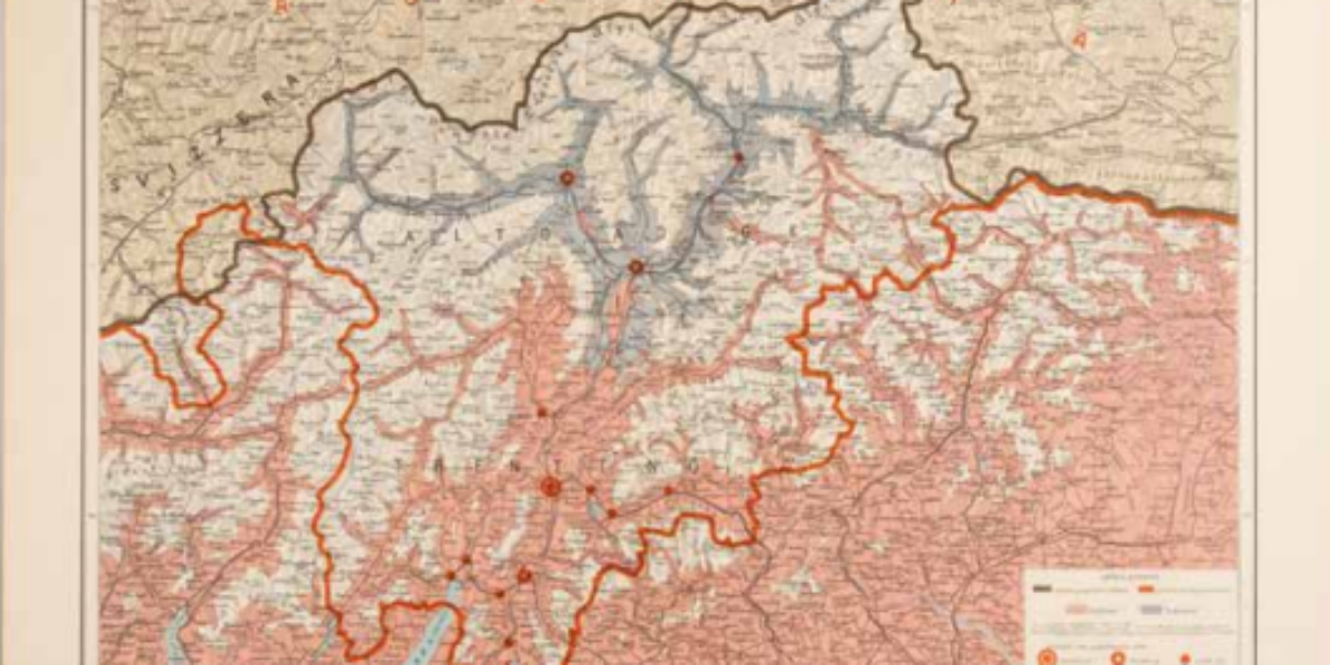
South Tyrol or Alto Adige This ethno-linguistic map serves as a tool to legitimise Italian territorial claims to the area situated between their established (red) border and what is defined as the ‘natural’ (brown) border, running across the watershed. Within this region, the majority of the population is depicted as speaking Italian (highlighted in pink)….
This is how the war stands The pamphlet cards titled ‘This is the state of the war,’ are issued every two weeks by order of the German army. The front side of this particular card from late July 1915 contains reports on recent fighting both on the western front and the eastern front. The course…
Blowing up hilltops below Ypres In this overview map, scaled at 1:40,000, Ypres takes a central position, with the village of Passchendaele situated to the northeast of the front city. This map highlights when the British army initiated a successful assault on the ridge located to the south of Ypres, which provided the German artillery…
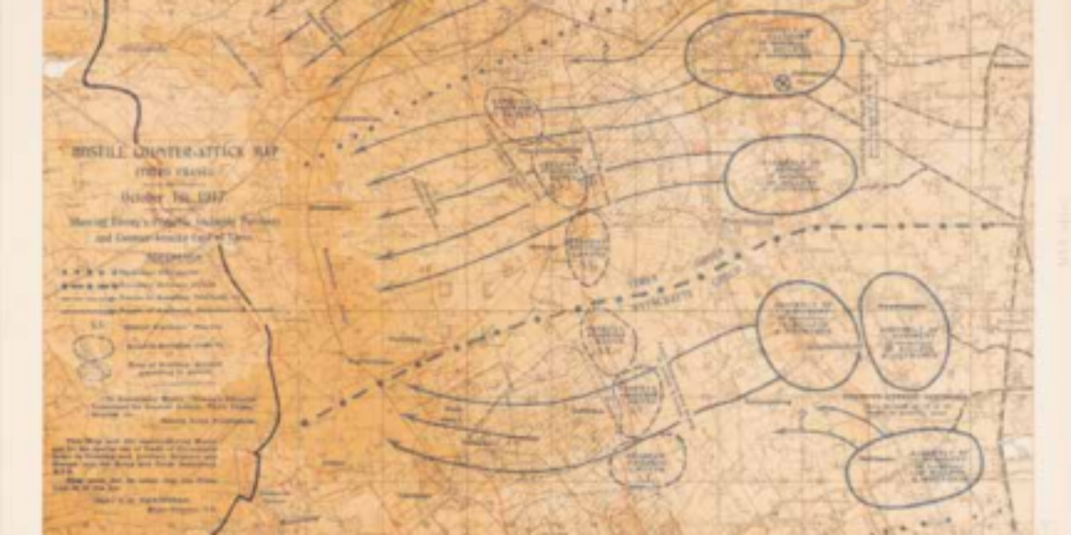
Map of expected counter-attack This map, scaled at 1:20,000, is used by British officers as they assess potential scenarios for a German counter-offensive on October 1, 1917. It marks trenches and fortified posts in red, while Passchendaele is prominently featured at the top, in the centre of the map.
Self-determination of peoples This propaganda map, which emerged in London, is a response to US President Wilson’s plan. In Versailles, President Wilson advocates for a rearrangement of the map of Europe based on the principle of self-determination of peoples within the tyrannical superpowers of Central Europe and the Middle East.
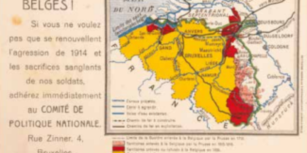
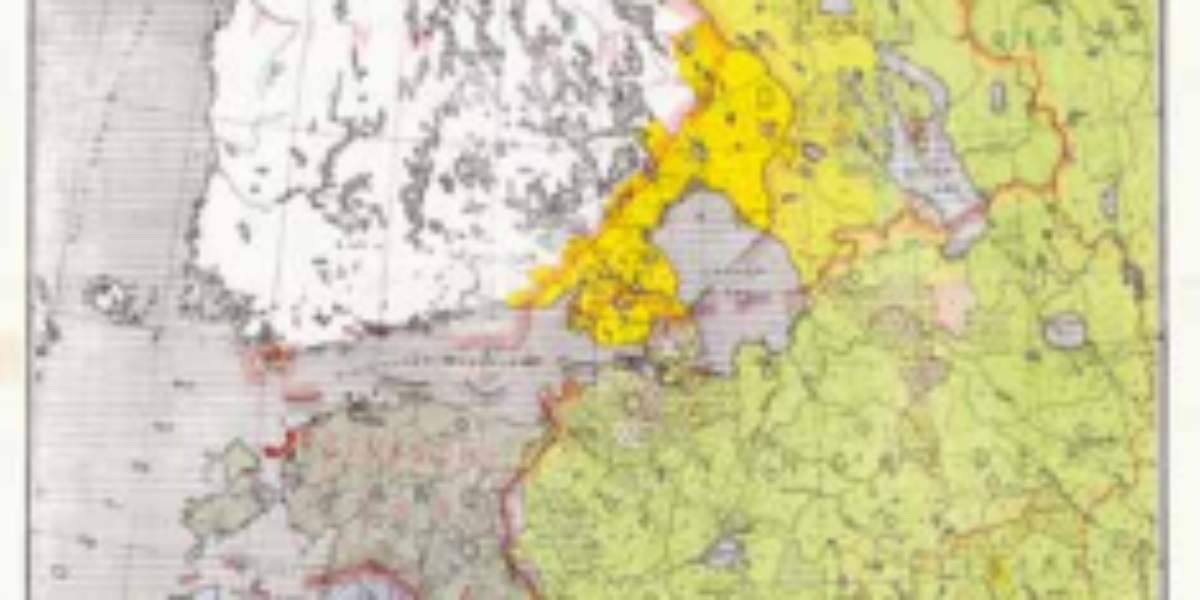
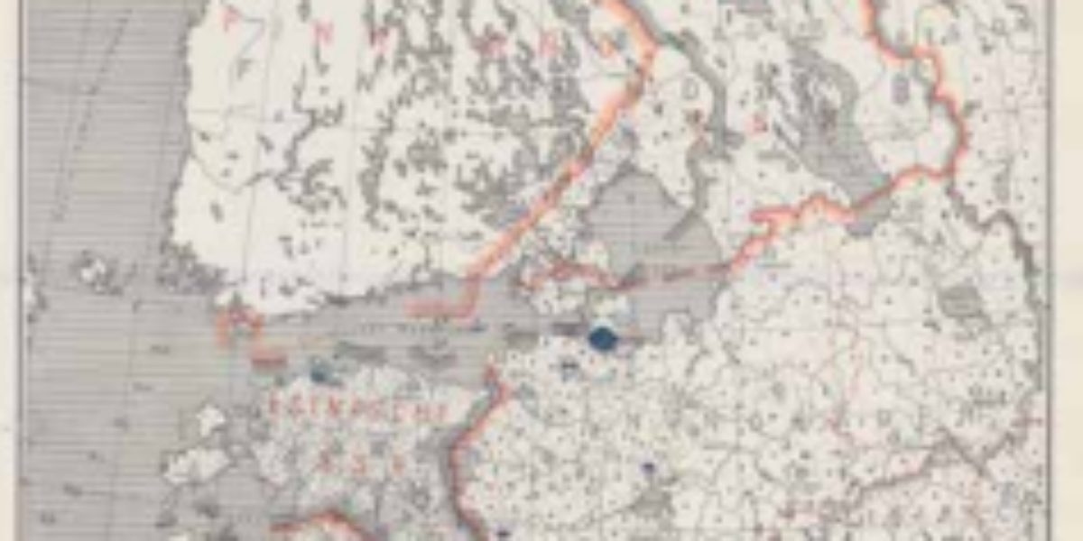
Claims of Greater Belgium The ‘Comité de Politique Nationale’ advocated for the concept of Greater Belgium, which aimed to annex several territories that had once belonged to the Southern Netherlands but had been under Prussian control for two centuries. Additionally, their vision included the return of Luxembourg, Dutch-Limburg, and Zeeuws-Vlaanderen to Belgian sovereignty. However,…
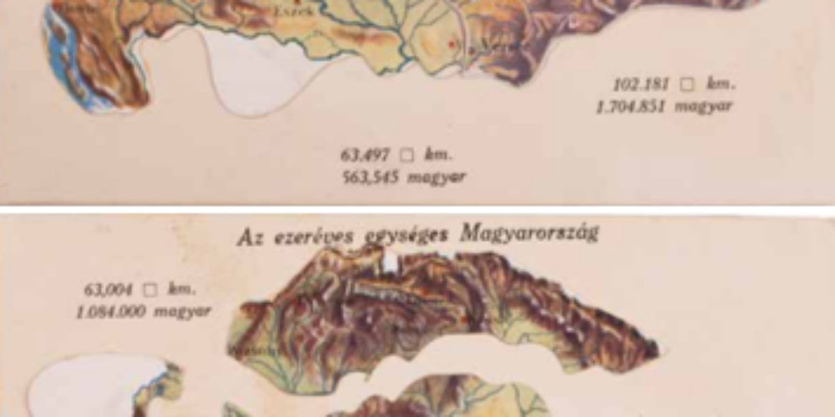
Hungary falls apart The movable postcard titled ‘Thousand-Year-Old Hungary’ represents the grief surrounding the dissolution of the Austro-Hungarian Empire following World War I. This traumatic historical event continues to resonate deeply in the collective memory of Hungary.
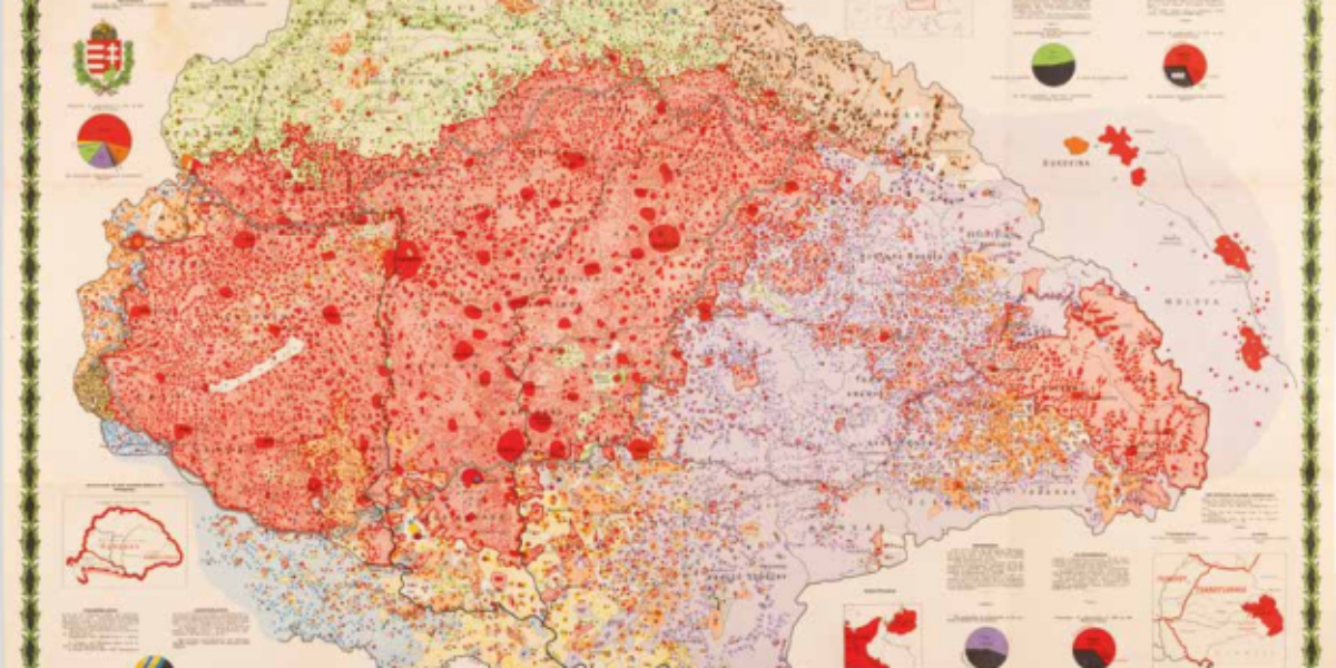
Ethnographic map of Greater Hungary This ethnographic map of Greater Hungary was designed by Károly Kogutowicz, a geography professor in Budapest. The primary criterion for classification on this map is the language that people speak most fluently. It not only delineates areas where specific languages are spoken but also highlights population density, using colour intensity…
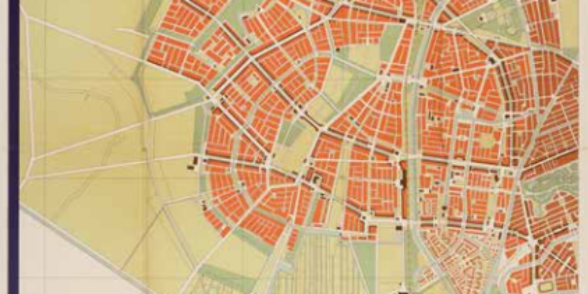
Berlage’s plan for ‘s Gravenhage Architect and urban planner Hein Berlage drew numerous expansion plans for several Dutch cities, including Groningen, Utrecht, and Amsterdam(-South). However, it was his expansion plan for The Hague that stands as his most far-reaching endeavor. Although not everything was implemented, this expansion plan determined the spatial development direction of The…
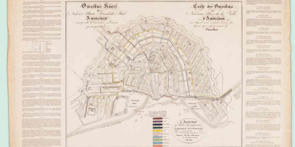
Horse-drawn tram of Amsterdam In congruence with the commissioning of the Amsterdam-Haarlem railway line in 1839, a private company was granted a municipal concession to operate an ‘omnibus’, a horse-drawn bus in the municipality of Amsterdam. This initiative marks the advent of modern urban logistics. We will have to wait only another 30 years for…
Cholera in Amsterdam The Netherlands experienced its final significant cholera epidemic during the years 1866-67, with the disease spreading rapidly in Amsterdam. It was during this period that maps assumed a pivotal role in charting and discovering the patterns of transmission, heralding the advent of spatial epidemiology. In 1854, in London, the scientist Dr. John…
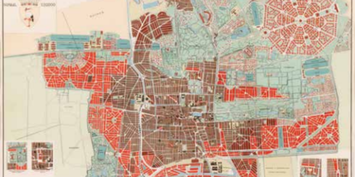
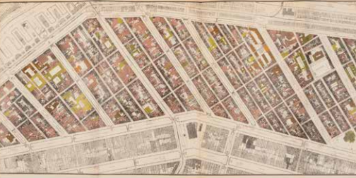
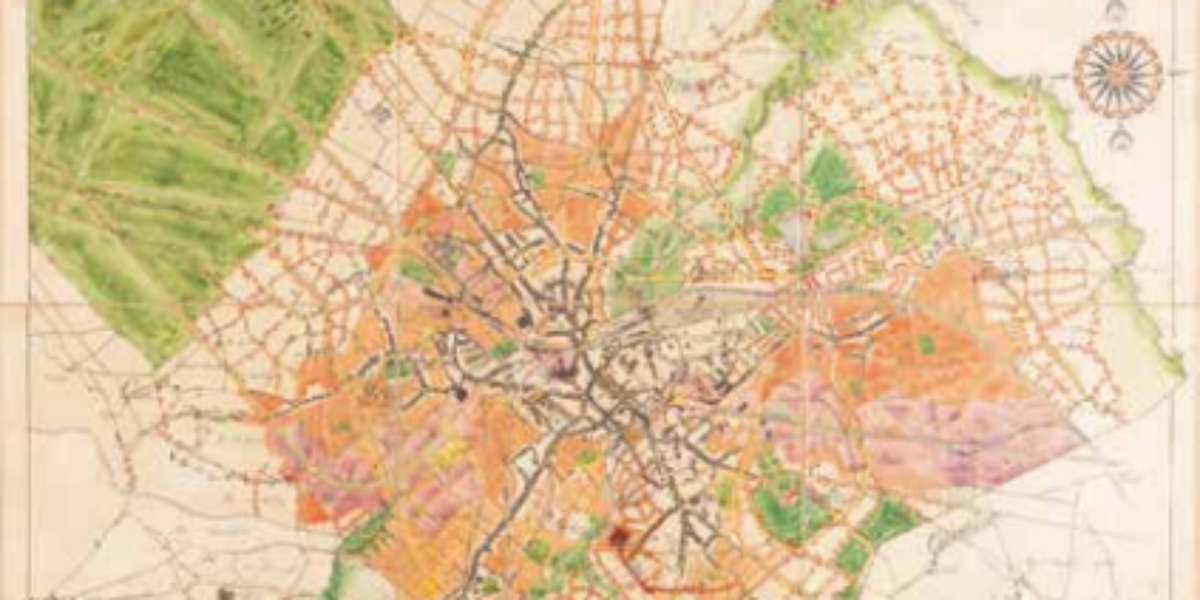
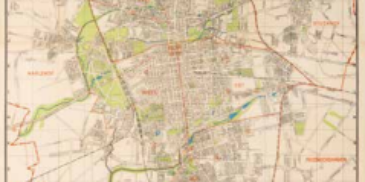
Spectacular growth of Amsterdam Starting in the mid-19th century, Amsterdam experienced a remarkable period of growth. This cadastral area map, once the possession of Mayor d’Ailly from 1946 to 1956, illustrates the city’s transformation beyond the Singelgracht, including space for new harbors, a cattle market, a slaughterhouse, cemeteries and parks.
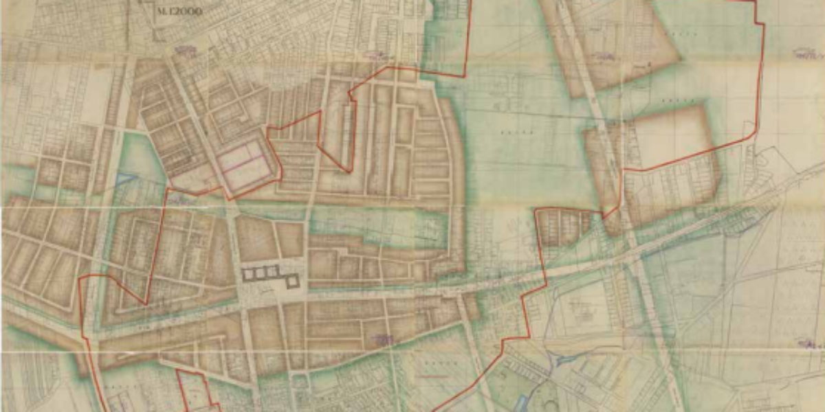
Amsterdam and resistance hotspot the Jordaan In the early 17th century, the Jordaan district found itself enveloped by Amsterdam as the city underwent urban expansion. This 1920 report takes stock of the (poor) housing quality, the density of habitation and the (widespread) absence of water pipes and toilets. This report strongly conveyed the enormity of…
Garden city in Amsterdam Rotterdam’s city architect, Willem Witteveen, develops a vision of ‘beautiful order’ for the westward expansion of Amsterdam, which he publishes in the pages of ‘Volkshuisvesting en Stedebouw,’ the trade magazine of the interwar period. The Art Deco inspired map reveals a plan for an expansive area that was never implemented.
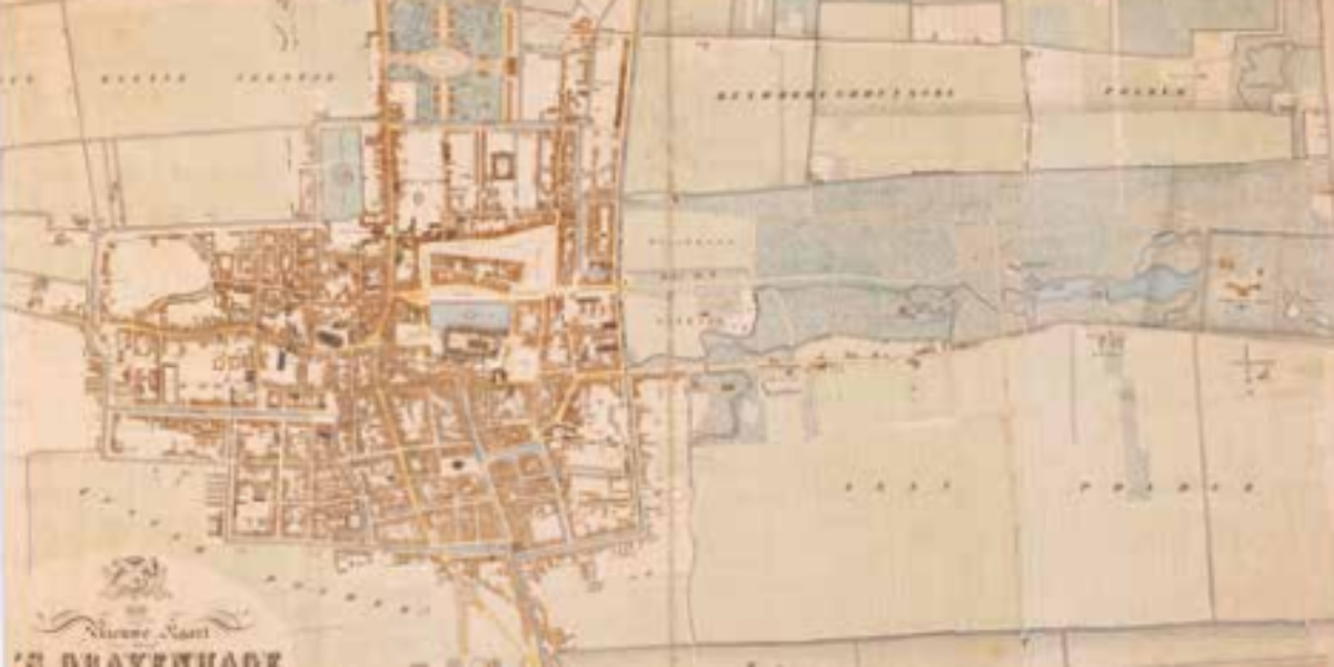
‘s Gravenhage embarks on modernisation In 1858, the administrative capital of the Netherlands had already witnessed a twofold increase in its population compared to a century prior. This cadastral map of The Hague shows little sign of modern urban development, though it does include a few remarkable details:. the roofs of the city’s churches are…
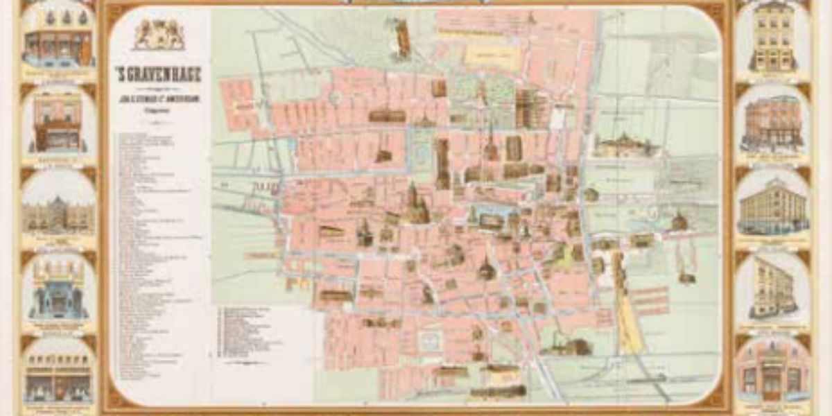
‘s Gravenhage as an early shopping city This tourist map offers a neat display of official buildings, but what is more captivating is the kaleidoscope array of business facades adorning the map’s border. These businesses, as depicted, likely helped in the creation of this early advertising map. This map captures a moment in history when…
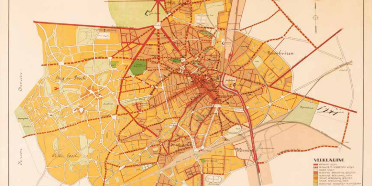
Eindhoven as a collection of villages Architect Joseph Cuypers from Amsterdam and Eindhoven’s city architect, Louis Kooken, collaborated to design the first General Expansion Plan for ‘Greater Eindhoven.’ As the name of the map suggests, the annexation of neighboring villages occurred before the plan’s conception, with its implementation not commencing until after 1920. The plan…
Apeldoorn: the largest village in the Netherlands The 1901 Housing Act stipulates that all municipalities larger than ten thousand inhabitants must draw up an expansion plan. Apeldoorn responded by creating a global plan in 1910. Transforming from a dormant royal residence, Apeldoorn grows into ‘the largest village in the Netherlands.’
Groningen also needs to grow This city plan for Groningen, by H.P.J. Schut, the director of municipal works, and his ‘advisor’ Berlage, is a true structural blueprint focused on infrastructure and building blocks. Nearly a century later, this plan still serves as a reference point, as demonstrated in 2020 when designers for the new Oosterparkkwartier…
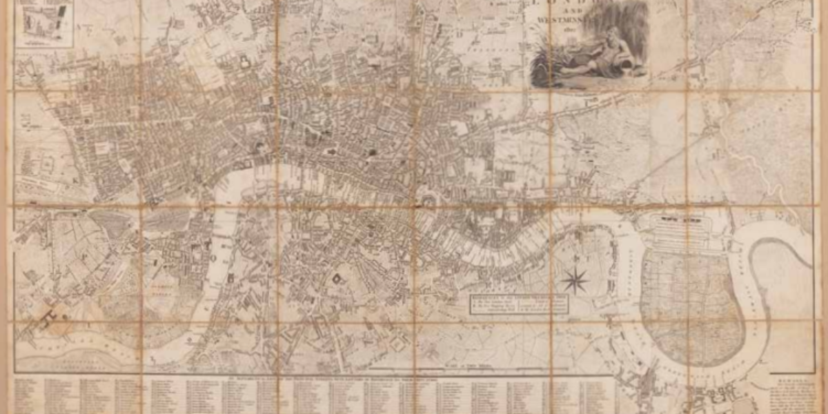
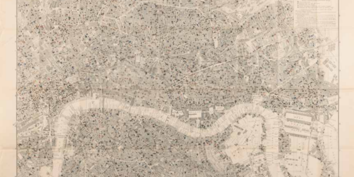
London modernises Amid the status of London as a world capital, a drastic spatial initiative is being planned: the development of the West India Dock, indicated on the right side of the map. These docks are set to mark a significant step in the modernization of London’s bustling port. The docks will herald the modernisation…
London prays, learns and drinks Around 1900, the social researcher and magnate Charles Booth created his iconic ‘poverty maps’ of London. In the culmination of his project, he charted the positions of churches, schools, off-licences, and pubs, effectively visualising the spatial interplay between virtue and alcohol. Surprisingly, his findings dispelled the notion that poverty is…
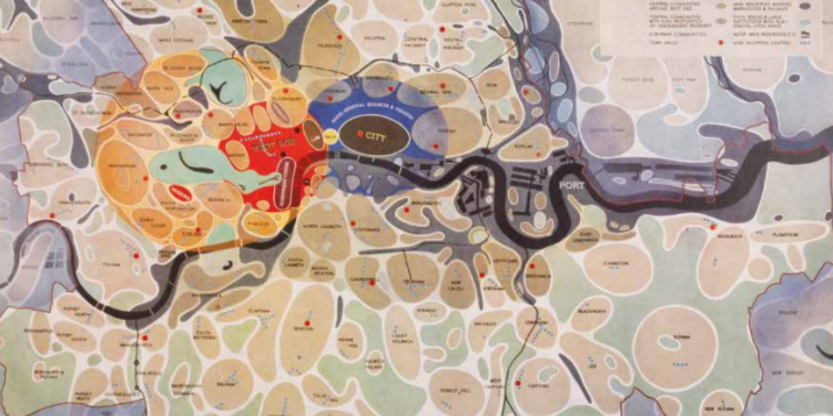
‘Potato’ Map of London During World War II, urban planners John Forshaw and Patrick Abercrombie outlined a vision for London’s post-war spatial development. Their plan envisioned neighbourhoods as a collection of self-sufficient islands, each with its own character, separated by green spaces and infrastructure. Little has come of this due to spectacular growth in…
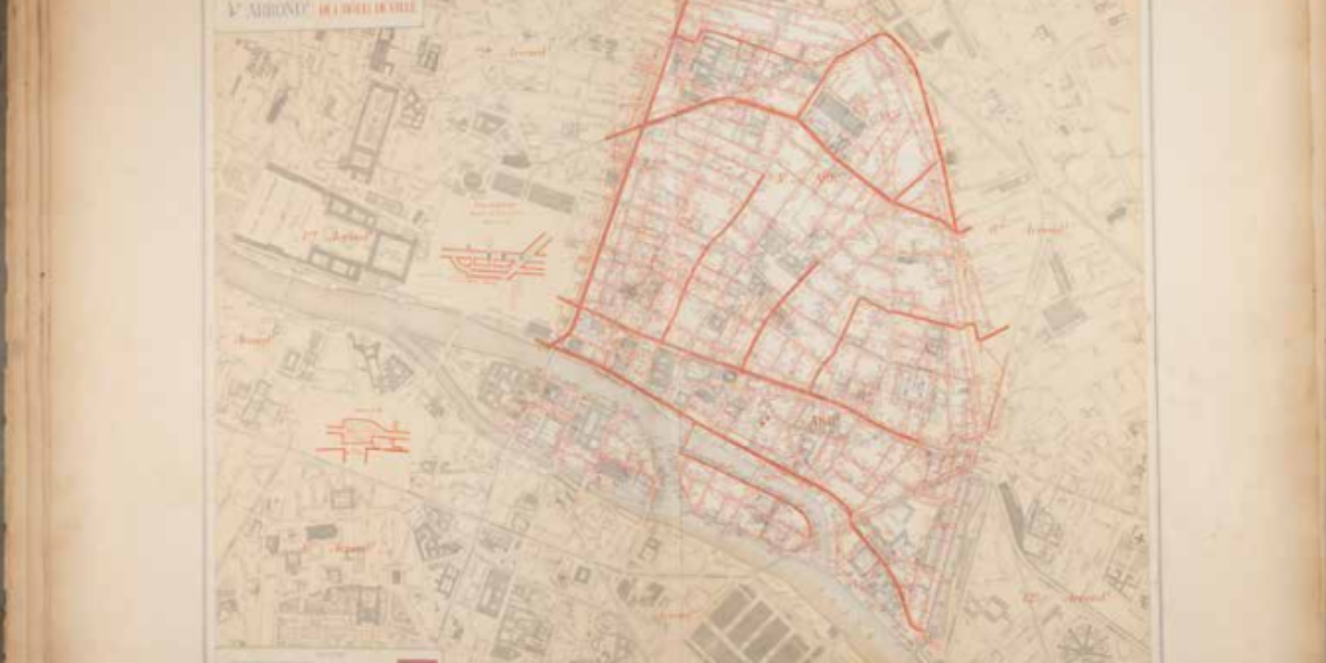
Modern Paris underground The Paris of 1900 wasn’t just characterized by its endless streets; it also boasted a thousand-kilometer-long sewage system. This unique underground Parisian network, featuring colossal pipes, has transformed into a present-day tourist attraction. Despite the French inclination toward state intervention and centralization, the construction of the Paris sewer system occurred relatively…
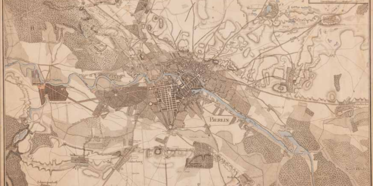
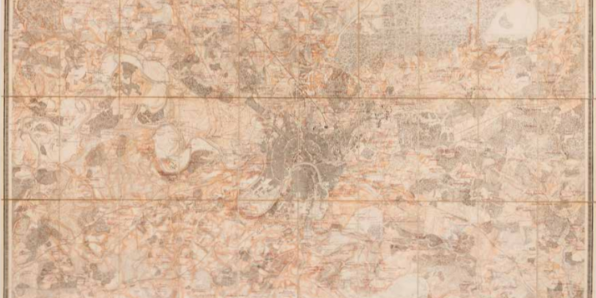
Premodern Berlin In the early 19th century, Berlin was a relatively compact European capital city, housing a mere 175,000 residents, making it even smaller than Amsterdam. What is particularly recognisable is the mediaeval core and a Renaissance city, seemingly fused together without real cohesion.
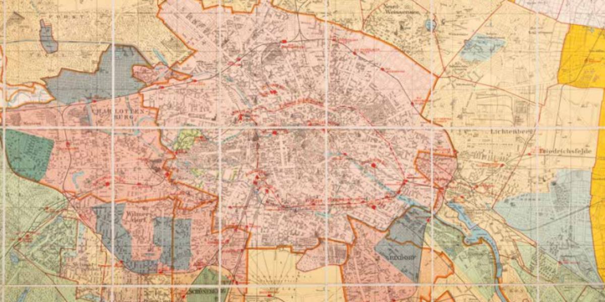
Building regulations against sprawl in Berlin At the beginning of the 20th century, Berlin transformed into a bustling ‘boomtown,’ experiencing an expansive growth. The metropolitan area now has three million inhabitants, propelling it to the status of the fourth-largest city behind London, New York, and Paris. This rapid expansion, characterised by chaotic growth, pushed the…
Moscow: developing power centre In 1712, Tsar Peter designated St. Petersburg as the capital of Russia. Yet Moscow retains its significance as an important city and a symbol of Russia’s eastern-continental focus. Emerging from the Kremlin, which served as the initial city wall, Moscow evolved into the political epicentre of the Muscovy region, eventually renamed…
Moscow, Europe’s largest metropolis In 2012, predating Putin’s re-election as Russia’s president, the internationally renowned Rotterdam-based design studio OMA received an invitation from Moscow city authorities to participate in a design competition involving ten companies. The objective was to influence the spatial development of Greater Moscow. OMA’s vision championed a multipolar approach to expanding Europe’s…
Cairo as a pre-modern city The Description de l’Egypte, a monumental collection of richly illustrated observations and inquiries, produced by 160 scholars and engineers during the Napoleonic occupation of Egypt from 1798 to 1801. Among its treasures is a captivating full-page etching portraying Cairo facing west as it stood around the year 1800, when the…
Cairo as a world metropolis Greater Cairo is the second-largest metropolis on the African continent, following Lagos in Nigeria, and is the largest urban area in the Middle East. In 2018, this sprawling capital was home to 22 million inhabitants, approximately 70 times more than in 1800. Both cutouts depict the entire region surrounding Cairo,…
Tokyo just before modernisation This ‘Fuku painted map of Tokyo,’ originates from the 3rd year of Emperor Meiji’s reign in 1855. This particular version is a partially supplemented reprint from 1879. The map already holds a resemblance to European city maps of the era, featuring a flat surface, defined streets, numbered buildings, and the highlighting…
European migration to Land of Freedom This German map illustrates the emigration of peasants, artisans, and Jewish refugees from Eastern Europe to North America in the mid-19th century. Following the unsuccessful liberal revolution of 1848-49, which aimed to transform the confederate German Confederation into a democratic German Empire, disillusioned citizens sought opportunities in “the land…
Travel Atlas to Amsterdam This survey map depicts the Kingdom of Holland, complete with land and water routes from Amsterdam, which wasn’t officially designated as the capital until 1808. At this point, Zeeuws-Vlaanderen and Limburg remained under French rule. The Meuse River serves as the northern border of the department of Brabant (encompassing Heusden, Woudrichem,…
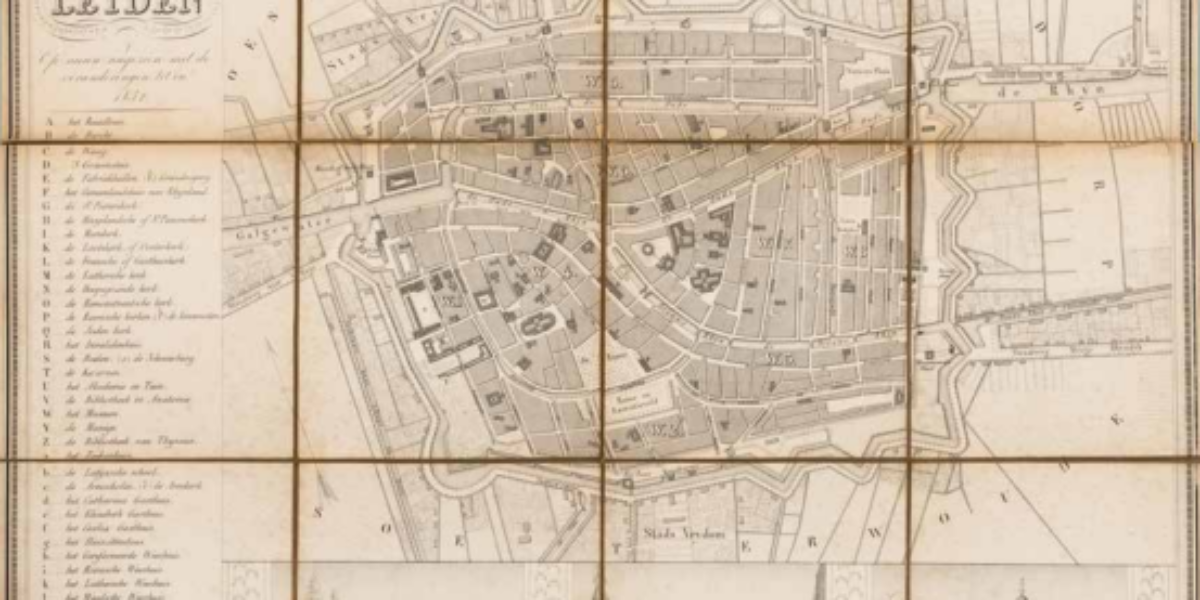
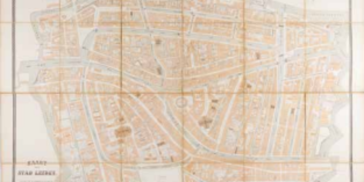
Leiden as an early tourist attraction This ancient folding map of Leiden serves as a guide for travellers. Notable attractions include the City Hall (A) with its tall tower, resembling a museum adorned with paintings and tapestries. High-end tourists are drawn to landmarks like the University Library featuring the Anatomical Theatre (V), as well as…
Skating sport as provision of work Ice roads are accessible for only a few weeks each year. They serve as alternative transport routes for businesses when ships can no longer sail due to frost. Unemployed individuals are employed to keep the routes skatable. The map also considers tourist skaters, with marked jetties for boat services…
Successful travel guide plagiarised Beginning in the 1930s, international publishers such as Murray and Baedeker gained popularity in the Western market with their “quick traveller’s guides.” Baedekers became so popular that Alberto Martinez illegally copied their model. His voluminous Baedeker of the Republic of Argentina for tourists and business travellers includes photographs, statistical tables, and…
Belgians‘ forgotten mass flight Following the fall of Antwerp in October 1914, Belgian civilians and soldiers flee en-masse to the Netherlands. Their numbers swelled to over 1 million. The soldiers are placed in internment camps, and one of the largest camps, with capacity for 15,000 soldiers, is located near Harderwijk. Many soldiers successfully escaped from…
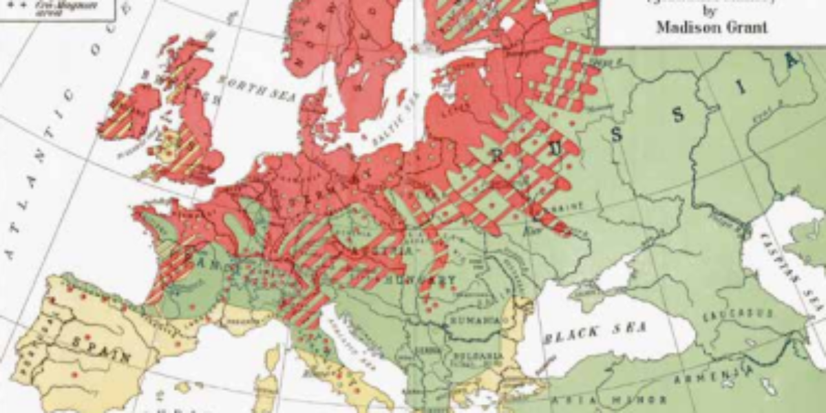
Racism as basis for immigration selection In this ‘popular science’ book, Madison Grant, a lawyer, conservationist, and eugenicist, puts forth the argument that Europeans are biologically and culturally superior to Asians and Africans. He argues for the existence of a natural hierarchy of races even within Europe. Grant advocates to restrict immigration from what he…
Tourism success with Olympics Since the inception of the ‘modern’ Olympics in 1896, the Games have consistently proven to be a major tourist attraction for the host countries. Despite the rising costs associated with hosting the event, city governments continue to eagerly organise the Summer Games as a means of showcasing their city on the…
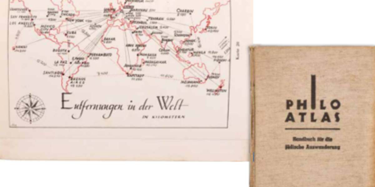
Handbook for desperate Jewish emigrants Occurring simultaneously with Kristallnacht (9th and 10th November, 1938), Berlin published this Handbook of Jewish Emigration. The guide contains an alphabetical list of countries with their professional opportunities and visa rules. But in this instance these details are not merely tourist formalities, but necessary information for survival. Which countries are…
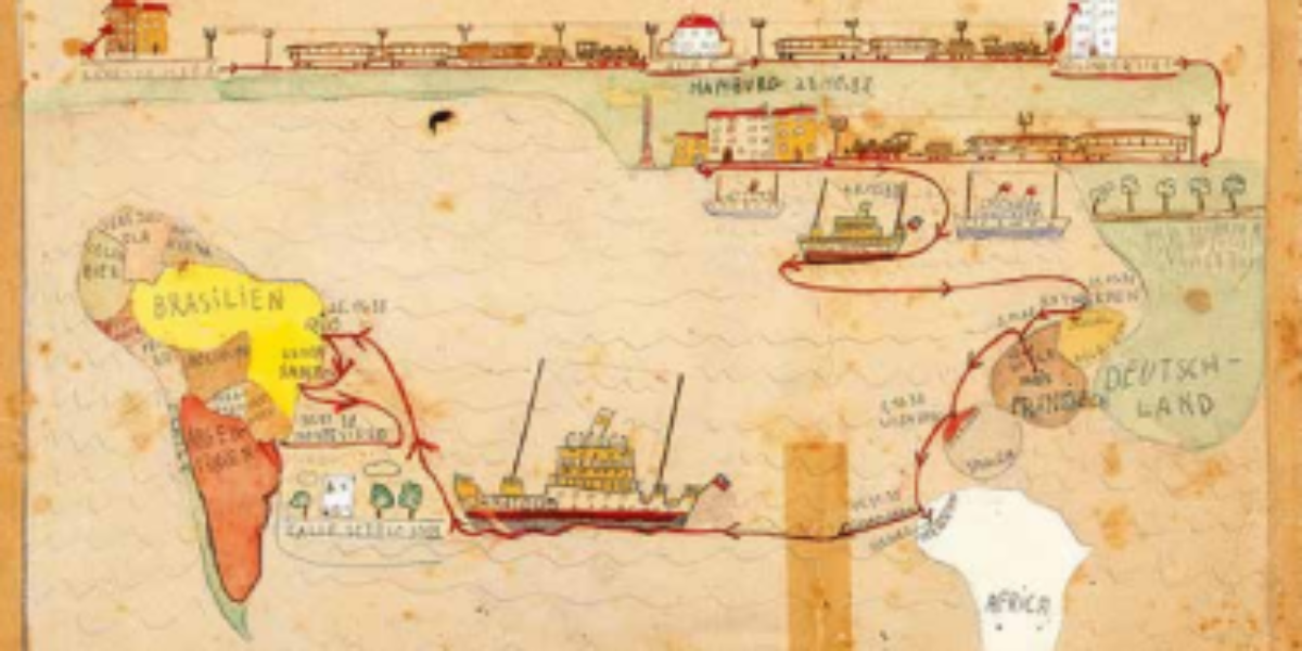
Successful flight through children’s eyes In the late months of 1938, the Freudenheim family managed to escape from Berlin. Amidst this journey, their 11-year-old son, Fritz, chronicles the various homes his Jewish family had occupied since 1925, tracing their voyage across the Atlantic: From the old homeland to the new homeland! After a six-week odyssey,…
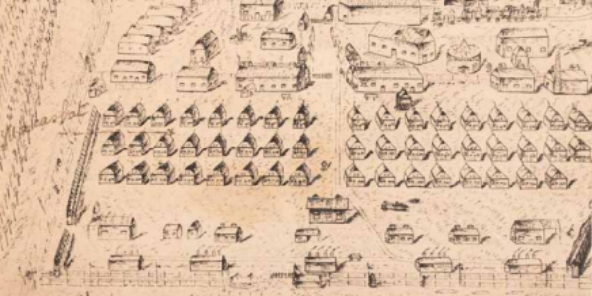
Nothing as permanent as temporary migration In 1951, the Moluccans, who had served in the Royal Dutch East Indies Army, found themselves ‘temporarily repatriated’ to the Netherlands, despite most of them having never previously been to the country before. Many of them ended up at Camp Westerbork, which was renamed Camp Schattenberg for this occasion….
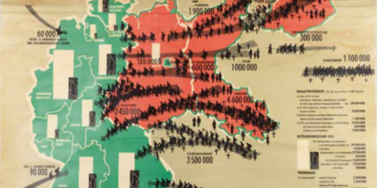
Mass expulsion of German losers This wall map of Germany provides a visual representation of the country’s 1937 borders, with the Federal Republic in green. The school map depicts the largest European migration of people in the 20th century. The term ‘Heimatvertriebenen’ refers to the German-speaking ethnic minorities ‘cleansed’ from Central and Eastern Europe, as…
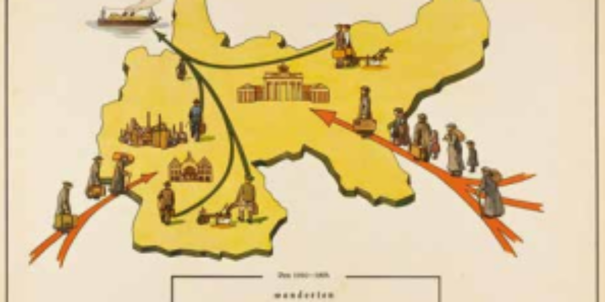
Netherlands emigration country, for a while In addition to the ‘Christian Emigration Central’ and the ‘Catholic Emigration Foundation’, the ‘General Emigration Central’ is a federation of social organisations that mediates for Dutch nationals who want to continue their lives elsewhere. This government-subsidised organisation helps find work overseas, as well as setting up retraining and language…
Fish tourism saves rural economy One of the attractions of the French Dordogne is its sport fishing, which this map shows in detail. Sports fishing associations can check various forms of compliance based on the information in this map. The rivers in the region are disrupted by numerous dams, referred to as ‘barrages.’, and due…
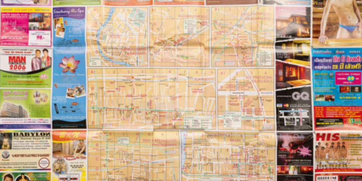
Sex tourism: source of exploitation Outside of Europe, the nations of Thailand, the Philippines, Brazil and the Gambia are havens of sex tourism. This Gay-Guide of Bangkok (complete with advertisements and a city map) promotes Thai young men who willingly and openly sell their sexual services to male tourists from rich countries. Although legal, this…
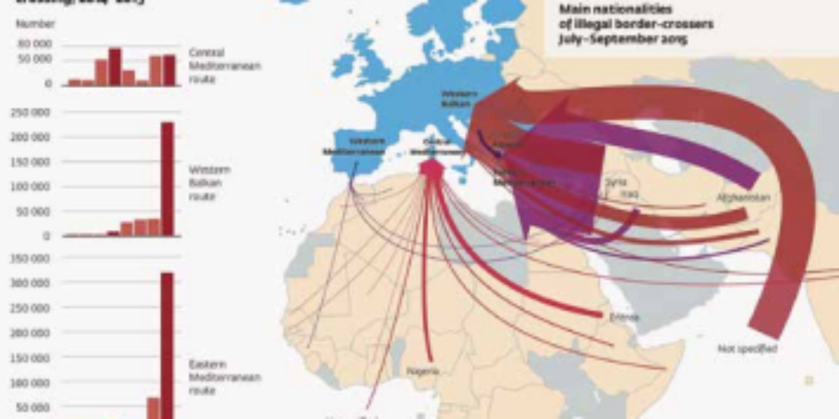
Unwanted and deadly migration This remarkable map produced by the European Border and Coastguard Agency presents the flows of illegal migrants en route to Europe. The thick flowing red and purple arrows, representing a ceaseless flow of millions of people, seems to suggest an invasion against which Europeans must defend themselves. In contrast, an alternative…
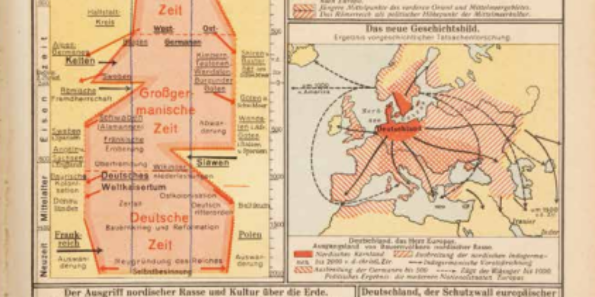
Germany cradle for Nordic race This school atlas marks a supplanting of the Nazi ideology of ‘thinking with the blood’ with ‘Bildung’ (humanist education). In the top right, the atlas outlines the paths through which urban culture ‘invaded’ northern Europe from the Middle East, via Greece and Rome. This map stands in contrast to the…
Gegenauslese – Population Starting in 1937, a set of 70 individual sheets were used in the curriculum of the upper classes at German folk schools in order to introduce students to the concepts of racial theory within the subjects of biology and heredity. This map draws attention to the threat of ‘repopulation.’ It illustrates the…
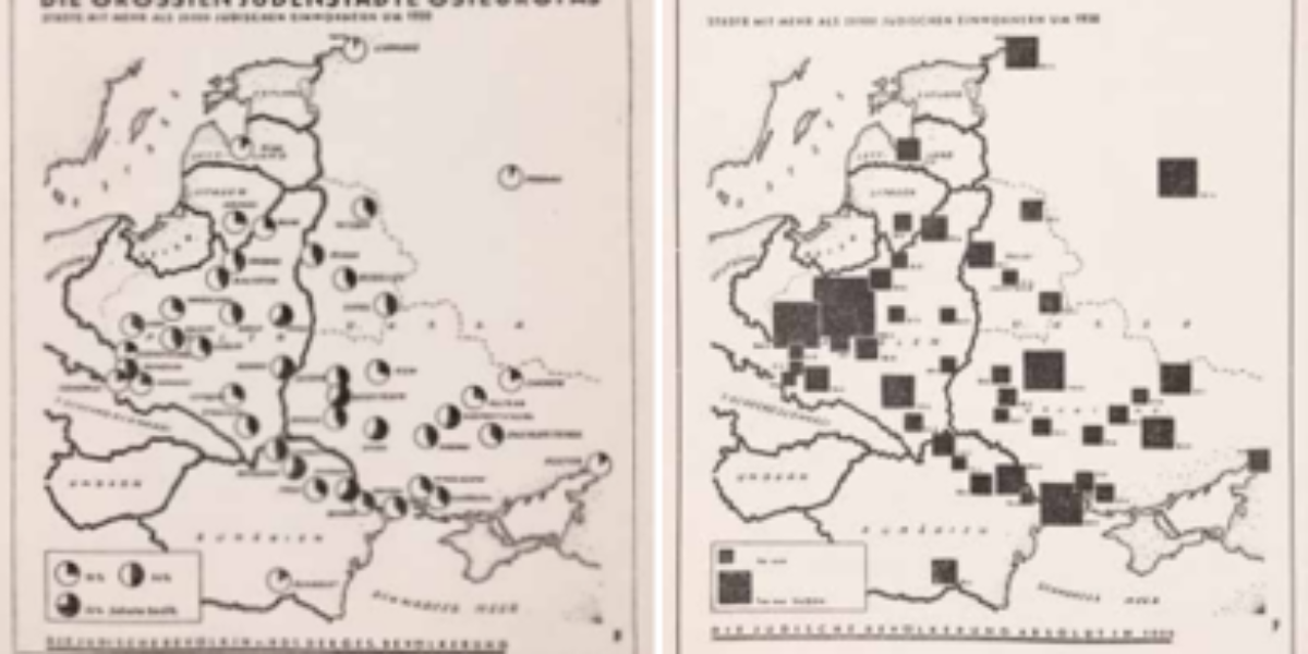
Jewish cities and ghettos On the left side, one can observe population figures for the ‘Jewish cities’ of Eastern Europe expressed in absolute numbers, while on the right, these figures are expressed in percentages. This Nazi-made work on Jewry in Eastern Europe posits that within cities and ghettos, the growing Jewish population is gaining prominence…
Westerbork transit camp Prior to the war, Westerbork in Drenthe served as a refugee camp for Jews, before being repurposed as a transit camp. Between 1942 and 1945, over 102,000 Jews, 245 Sinti, and dozens of resistance fighters were transported from here to the east. This map was made by Werner Löwenhardt, a German-Jew. His…
Trains to extermination camps Departing from Westerbork, 93 severely overcrowded trains depart for a secret ‘labor camp’ situated somewhere in the eastern region. Typically, these trains followed a path through Assen, Groningen, Nieuweschans, Bremen, Wittenberg, to Berlin-Spandau. From there, the transports continued through to Breslau, then to Czestochowa, ultimately turning south and ending at Auschwitz.
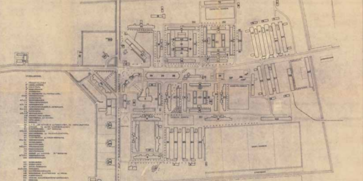
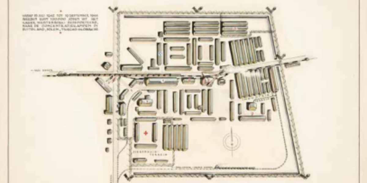
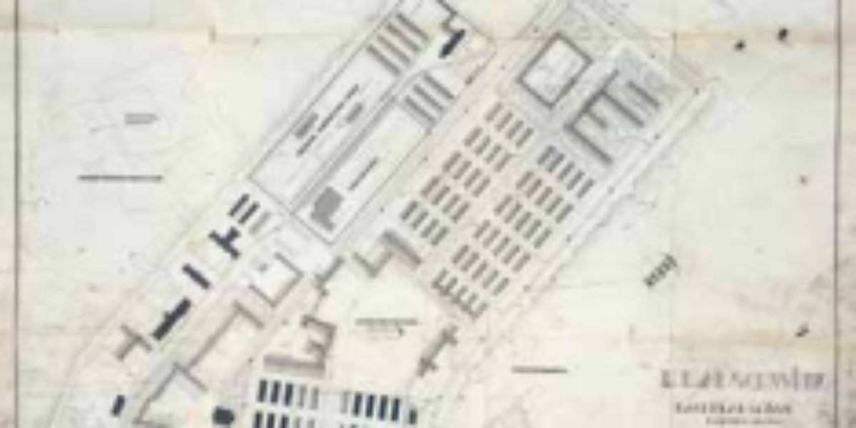
Auschwitz I expansion plan The Auschwitz concentration and extermination camp, established in 1940 as a single camp with 22 buildings, evolved into a vast complex with three main camps by the end of the war . This map, dating from April 1942, outlines the expansion plan for Auschwitz I, which includes a roll call area…
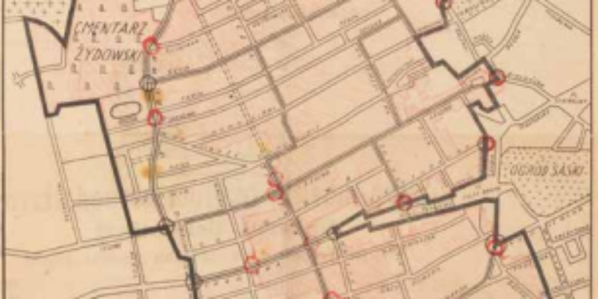
Plan for a Jewish quarter Under orders from the occupying forces, the Nowa Kurier Warzawski publishes this plan on 15 October, 1940. All Jews residing outside this demarcated area were required to relocate to a newly established ghetto, situated around the old Jewish quarter, within a matter of weeks. This decree triggered disputes between ‘Jews…
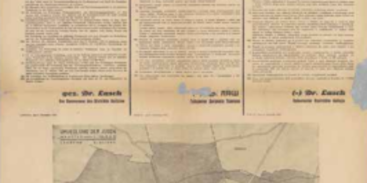
Walking routes to the ghetto in Lemberg This rare trilingual street poster, issued by the German governor on November 8, 1941, compels Jewish residents in Lemberg/Lwów/Lviv to settle in two slums located north of the railway line. The ghetto’s location was chosen by the newly appointed Ukrainian mayor. The poster includes mandatory dates and…
Ghetto cards in memorial books Beresteczko, situated in the Wolhynia district of what was once Poland (now Ukraine), was home to some 2,500 Jews, constituting roughly one-third of the population. In October 1941, the Germans established a ghetto in this area, as indicated by the barbed wire line on the map. Around September 8, 1942,…
Mental maps of Shtetls In the absence of professionally-made maps, groups of survivors made new maps of their destroyed communities for their memorial books, known as ‘Jizker-bicher.’ These ‘mental maps’ didn’t adhere to topographical standards; rather, they served as testimonials to the world they had lost. For instance, in Yanova, where 80% of its 4,000-strong…
Ethnic distribution Northwest Russia During the war years, the Nazis considered it indispensable to have precise information about the locations of pro-German ethnic minorities. On this map encompassing Lithuania and Poland, dots are used to indicate the main minority groups living within the territories of dominant ethnic groups. Borders from 1939 are in black, while…
Expansion of Jews in northwest Russia In this map, dot symbols ranging from less than 10 to 100,000 (represented by the Star of David), illustrate the numbers and distribution of Jewish populations. The map is a compilation of ethnic studies conducted well before June 1941. Such maps were used in preparations for the identification, segregation,…
Warthegau as ‘blonde utopia‘ This map shows ‘the heart of the German East’ and serves as a compact representation of the Nazi ‘blood and soil’ ideology. The wall map portrays a landscape populated by farmers, forest workers, and artisans, featuring two major cities, Posen (Poznań) and Litzmannstadt (Łódź). A crucial issue with this envisioned ‘blonde…
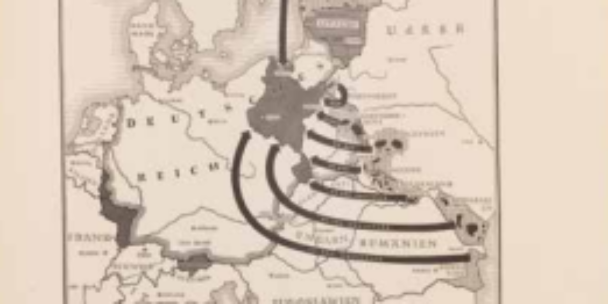
Back home in the Empire Volksdeutsche are people who are considered Germans even though their families have lived in other countries for several generations, or even centuries. This 1941 map shows the forced relocation as agreed in the Hitler-Stalin Pakt. Approximately 426,700 Volksdeutsche, originating from the Romanian Dobroedja region to Estonia, were tasked with Germanising…
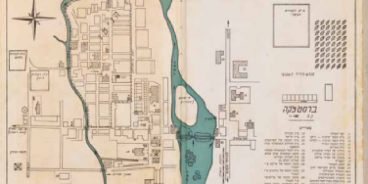
Ghetto without street names The Nazis transformed Łódź into Litzmannstadt. This map, featuring German street names, omits the barbed wire boundaries of the ghetto. Nevertheless, the area of this first (and ultimately last) major ghetto remains easily identifiable. Streets within the ghetto are identified only by numbers and letters, implying that Jewish residents would tarnish…
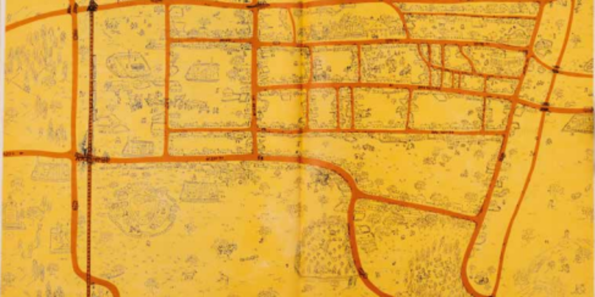
Concrete utopia of German Lebensraum In January 1943, the urban planning department in Litzmannstadt designed a new city centre for the German population, featuring streets for parading and a roll call square. This was superimposed onto a cadastral map of the Jewish ghetto. Although it was limited in its implementation, this ‘concrete utopia’ of…
Localising the unimaginable When this map found its way to New York, Treblinka II was in the process of being dismantled following an uprising. The origin of this image can be traced back to a manuscript card from Warsaw, dating from late 1942. Within the confines of the ghetto, Rachel Auerbach documented the account of…
Jewish partisans In West Belarus and Wolhynia (northwest Ukraine), Jewish resistance fighters regularly allied with anti-fascist partisans who operated in the region’s forests and swamps. An underground Jewish bunker community emerged, housing over a thousand men, women, children, and elderly individuals. This clandestine settlement featured essential facilities such as a field hospital, prison, school, and…
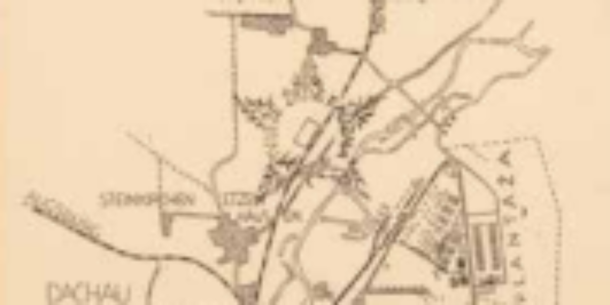
Dachau: camp and city after liberation These maps of the oldest SS concentration camp Dachau and a nearby mass grave were made at the camp by Marko Zupančič. He published these maps in the “first and hopefully last newsletter” by and for Slovenian partisans on June 1, 1945. This publication came a month after the…
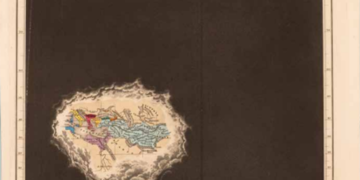
Clouds of western ignorance With 21 maps, Edward Quin’s atlas presents all political changes from creation in 2348 BC. At crucial moments of history, from a celestial perspective, worlds known at the time light up amid dark clouds. By passing the eye quickly over the engravings, with the same territory in the same place, the…
Earthly precision and celestial reference Due to the large scale here, all plots can be drawn separately and no separate legend is needed. Buildings are always shown in orange according to their exact ground plan, except for the churches and the synagogue (Israelit. Kerk), where the roof structures are coloured brown. But in this reference…
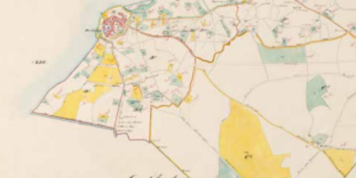
Harderwijk cadastral map Since 1832, the Land Registry has been registering land ownership: every plot of land is measured and mapped. Owners are hereby registered so that the government can levy taxes on land ownership and property disputes can be settled.
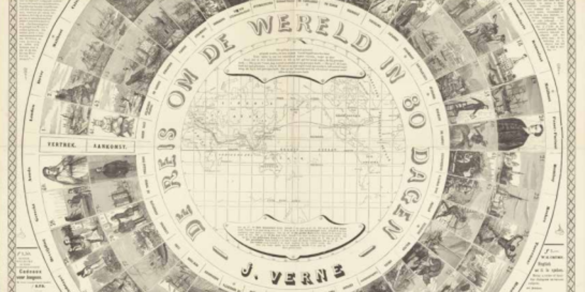
Journey around the world in eighty days The time-honoured Game of the Goose is adapted here from Jules Verne’s popular novel Journey around the world in 80 days. For a wager at his London Reform Club, gentleman Phileas Fogg (10) travels eastwards around the world (see map) with his French servant Passepartout (20), overcoming various…
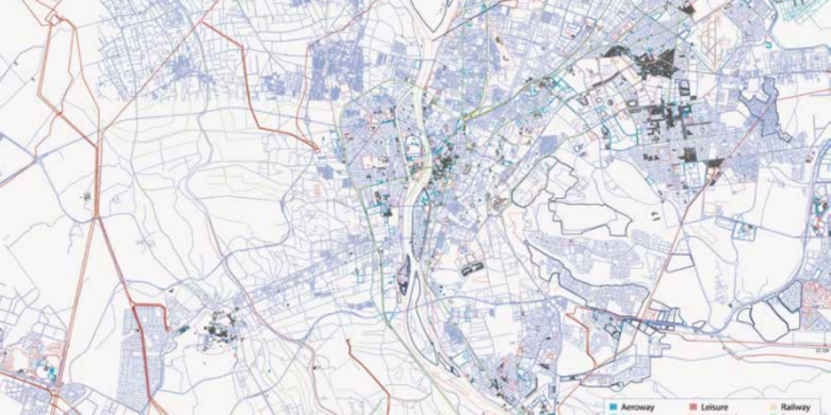
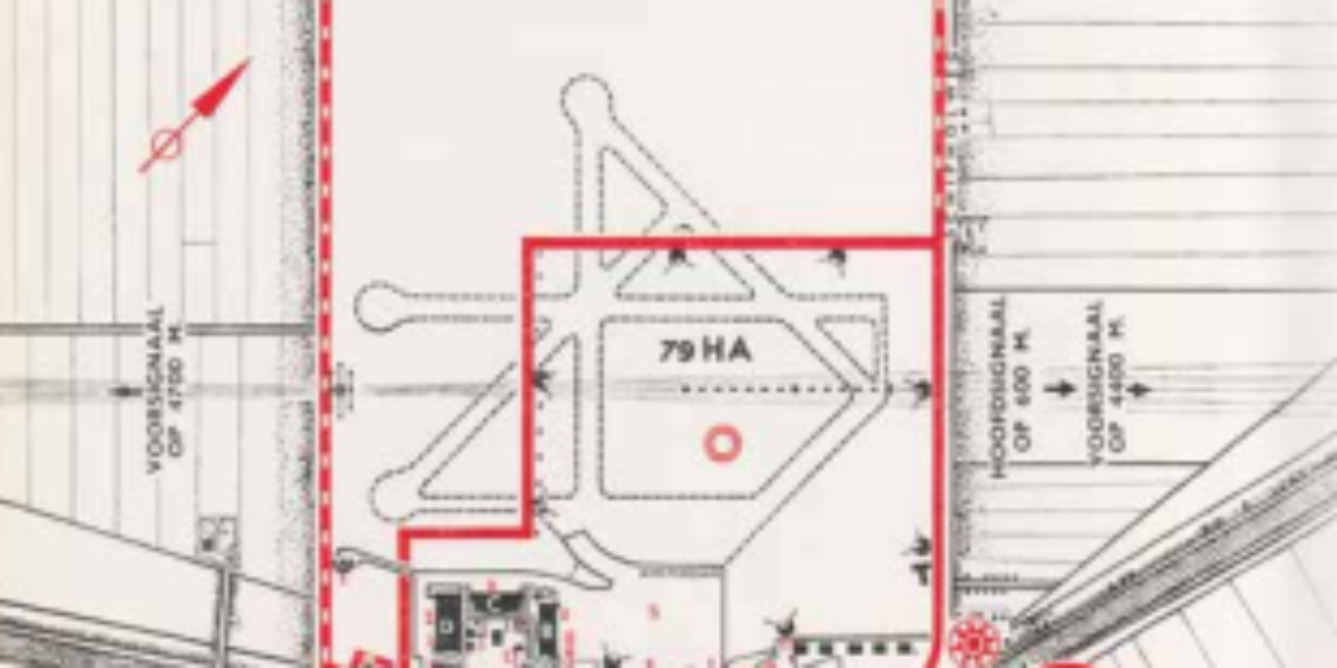
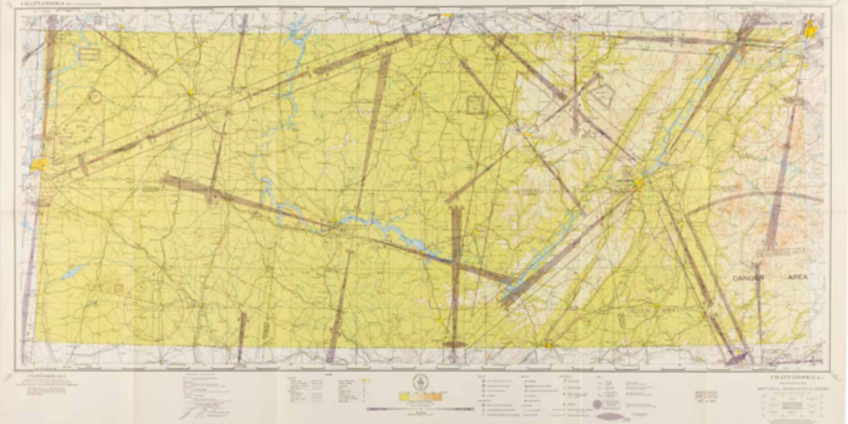
Schiphol day and night This map shows the expansion of the airport in 1935: from 79 to 210 hectares (compared to 2787 hectares in 2023!). There is also a night landing facility set up and four asphalt concrete runways, instead of grass. This results in continuous flights also in the evening and at night and,…
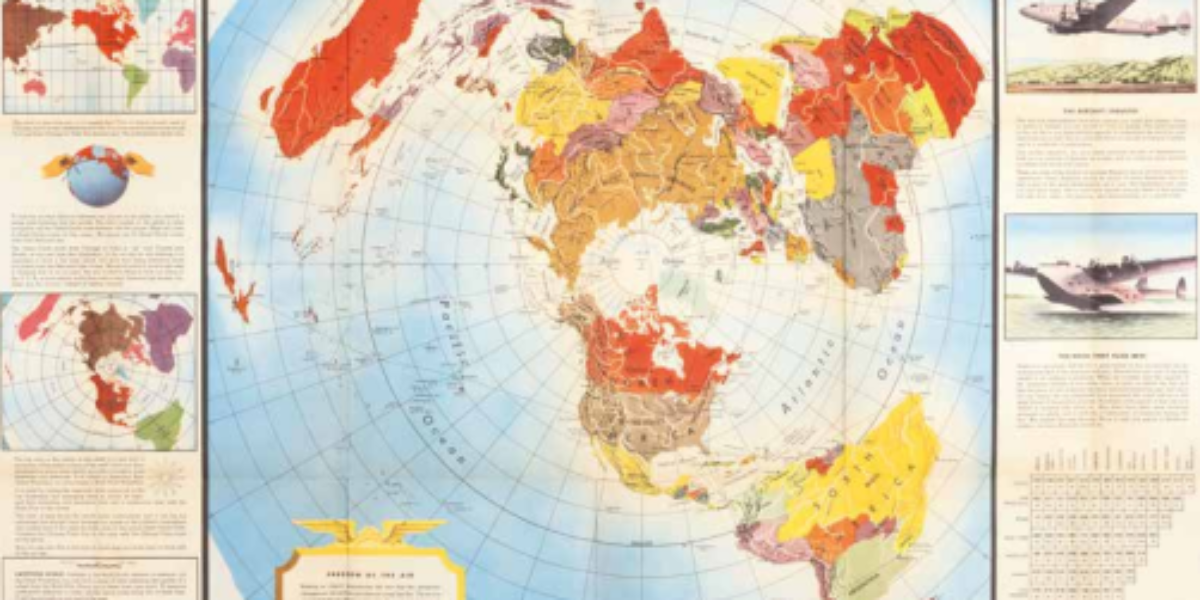
Shrinking the world This world map was designed by magazine illustrator Antonio Petrucelli in 1943 and published by US company Alcoa Aluminium. The North Pole is at the centre. Of interest to the company is the logistical advantage of the shorter route between Chicago and Tokyo, which this North Pole projection compares with the longer…
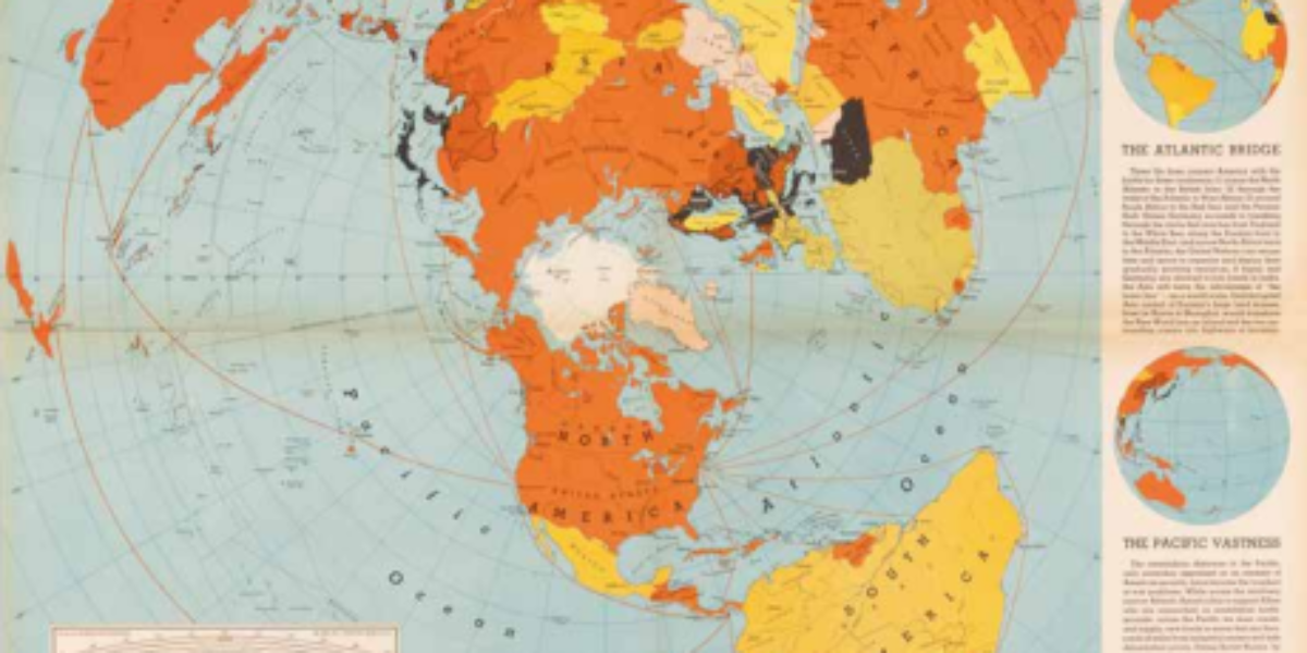
One world, one war Edes Harrison argues with this map that the proximity of the northern continents makes the United States the strategic hub for trade and security. The ‘Air Map’ exudes that modern air travel enables direct air connections, and borders between oceans, continents and countries are no longer relevant. Visually, this is reinforced…
Flying by sight and radio beacons ‘Sectional Aeronautical Charts’ are indispensable for pilots navigating primarily by sight; the 1:500,000 scale is intended for civil aviation at speeds up to 600 km/h. In addition to colours and contour lines for relief, the chart presents visual landmarks for navigation under visual flight rules. Striking are the purple-brown…
Aeronautical map of the Netherlands With these 1:500,000-scale maps combined with electronic means navigation equipment, pilots can determine all relevant things: their position, safe altitude, the best route to a destination, alternative landing areas, radio frequencies and airspace boundaries.
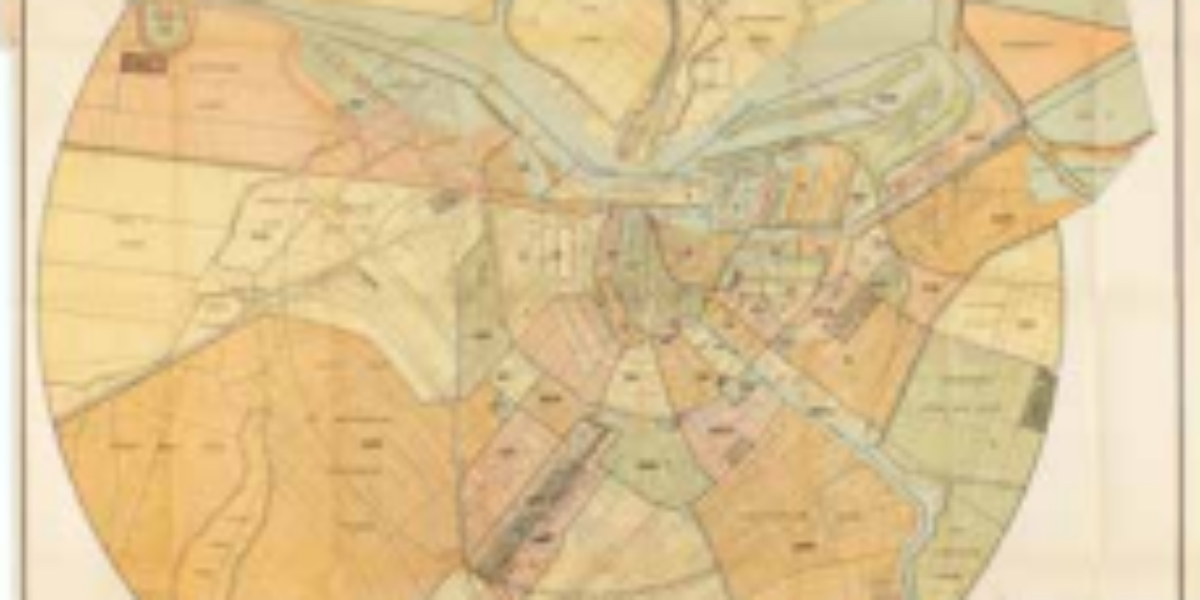
Amsterdam municipal telephone This circular map of Amsterdam with the Westertoren as its centre shows for each neighbourhood where the telephone lines continue above ground: the take-off points. Although most connections are still within the ring of canals, the network has spread further into several districts.
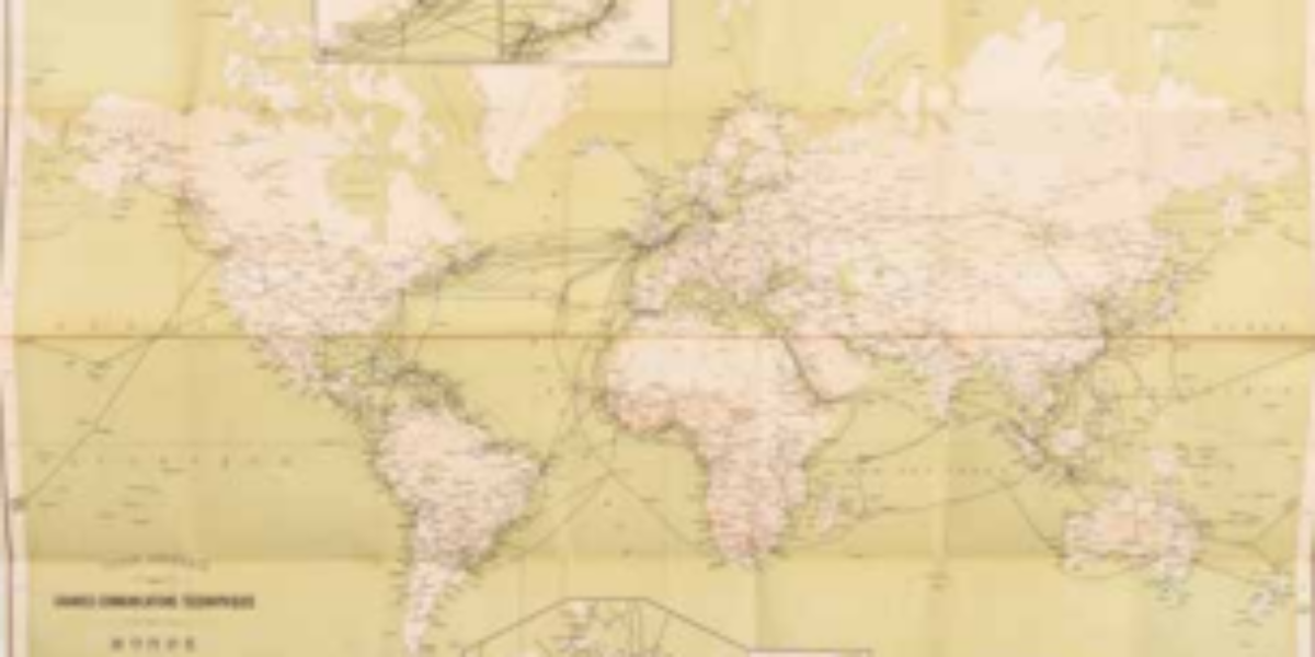
World network telegraph communications This map presents the international network of existing and projected telegraph cables. The network of radio telegraph links plays a decisive role in the globalisation process before World War I.
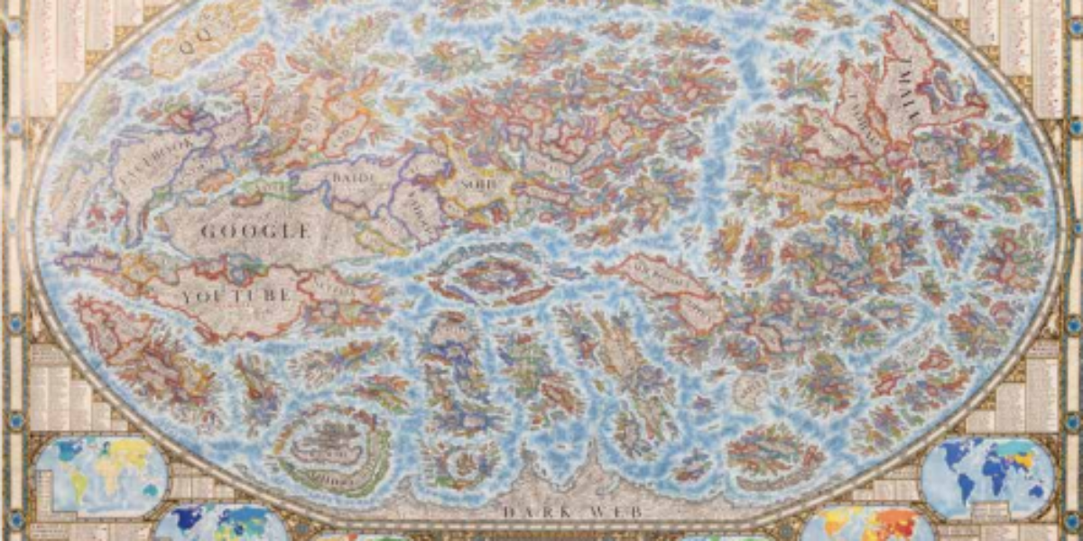
Baroque internet map This internet map visualises the worldwide web and documents the most popular websites of 2021-22. Thousands of websites are presented as ‘countries’ and grouped with similar websites into ‘regions and continents’. Their features, services and creators are labelled as ‘cities’. The stronger their mutual links, the closer the websites are to each…
Universal atlas The encyclopaedic geographer and self-taught cartographer Philippe Vandermaelen is the creator of the Atlas Universel, the first world atlas with 400 maps on the same scale. Here you can see the overview sheet for the 76 sheets of North America. He then publishes an Atlas de l’Europe on 165 sheets, with a scale…
International maps of the world In 1891, the ‘International Map of the World’ project was launched to provide ‘a politically neutral representation of geographical facts’. Only decades later an agreement was reached on the Greenwich prime meridian, while the metric system was used for scale. When this utopian project was finally completed in 1986, its…
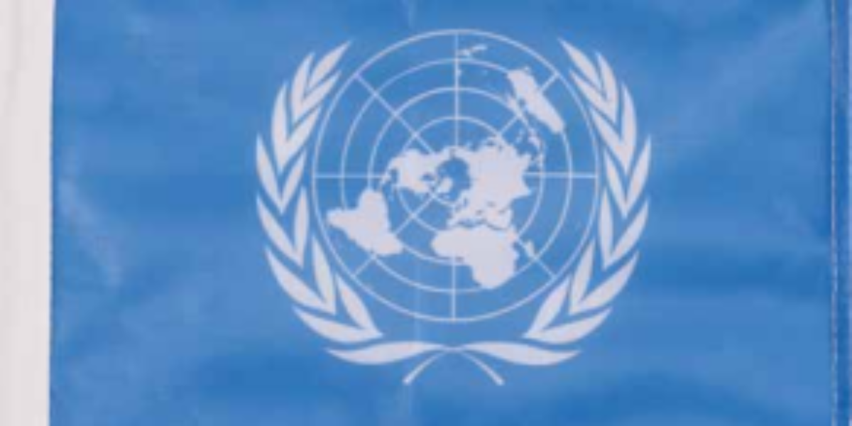
Quarter turn for the United Nations This boat flag with the United Nations emblem presents a world map centred on the North Pole, surrounded by two olive branches symbolising world peace. This is the second version from 1946, rotated a quarter turn clockwise to avoid the appearance of favouring the United States.
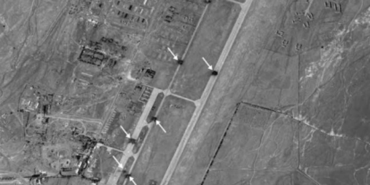
Glocalisation of cruise weapons October 2001, US, British and allied forces, together with the Afghan Northern Alliance, launch their offensive against the Taliban, Bin Laden’s supposed protectors. In the process, the concrete airstrip of Shindand airbase is also hit by cruise missiles (see arrows in this aerial photo). This attack is not based on large-scale…
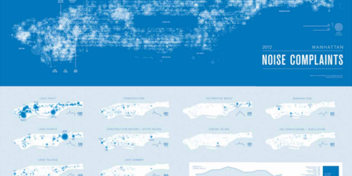
Noise pollution Manhattan Monochrome maps here locate and classify 40,412 noise complaints in Manhattan in 2012, which came in through the city’s complaint line. This thematic map by Brooklyn-based designer Karl Sluis is not based on a simplified topographic map like Google Maps. His visualisation of mass data creates an overview map of the “noisiest…
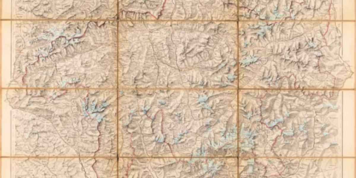
Melting roof of Europe Many of the extensive glaciers depicted on this late 19th-century Alpine map, represented by the blue fields, have disappeared altogether, as evidenced by the Zapport Glacier (2b). During a dry summer, 20% of the Rhine’s flow comes from glacier meltwater, but what will happen in the future as glaciers continue to…
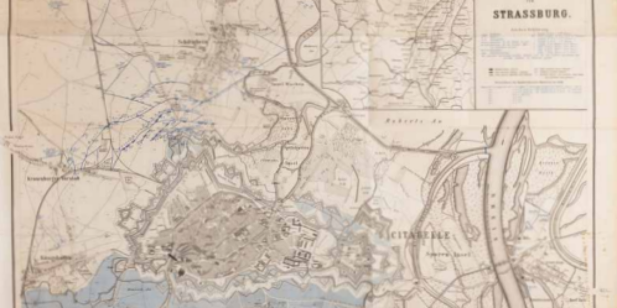
Water as an ineffective means of defence In the Franco-German War of 1870-1871, Strasbourg, one of France’s most modern fortresses, was besieged by troops from Baden and Württemberg. The extensive damage was attributed to the artillery shelling employed during the siege. This highlighted the vulnerability of traditional, static fortifications in the face of a highly…
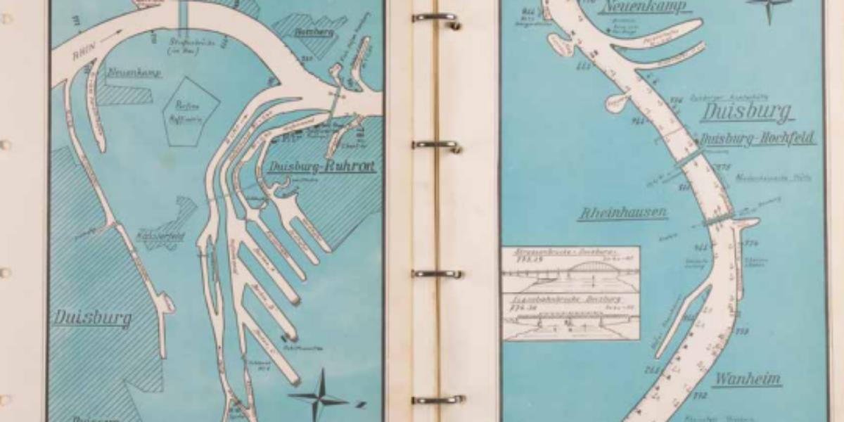
The Rhine as a modern transportation route This atlas served as a navigational tool for ships in a time predating the advent of radar and GPS technology. Over the course of a century, the Rhine River underwent modifications to accommodate modern navigation requirements. It wasn’t until the salt discharges from Alsace, which continued until 1998,…
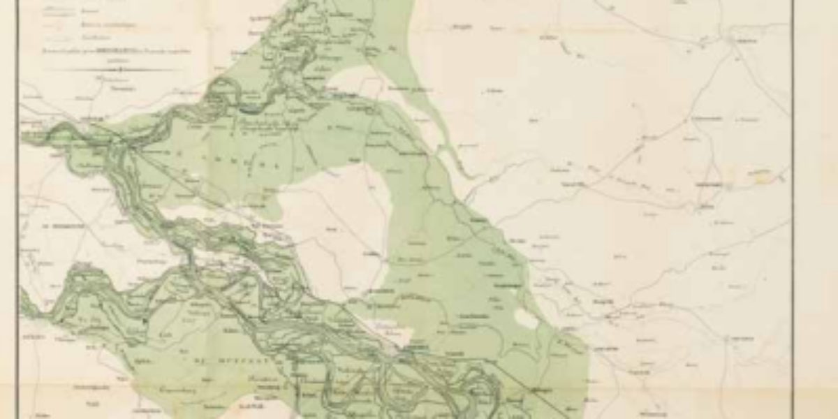
The power of the swelling Rhine During periods of high water levels in the Rhine, the river valley experiences inundation. This flooding highlights the size of the valley, despite the protective dikes built along it for centuries. The changing climate and the loss of upstream catchment basins cause larger volumes of water to occasionally flow…
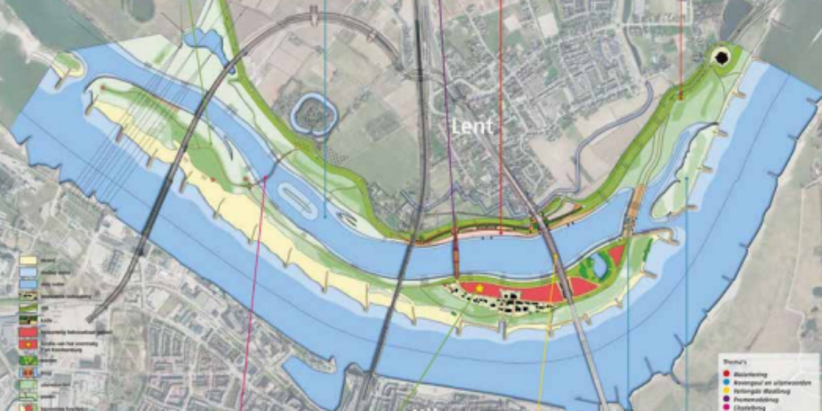
Room for the river, everyone wins In 1995, 250,000 people had to be evacuated from the Betuwe region due to the precarious state of the dikes. This event led to a shift in approach: The “Room for the River” initiative is a billion-dollar investment program with the aim of creating additional space for the Rhine…